Colorado Plateau
Plateau in southwestern United StatesThe Colorado Plateau is a physiographic and desert region of the Intermontane Plateaus, roughly centered on the Four Corners region of the Southwestern United States. This plateau covers an area of 336,700 km2 (130,000 mi2) within western Colorado, northwestern New Mexico, southern and eastern Utah, northern Arizona, and a tiny fraction in the extreme southeast of Nevada. About 90% of the area is drained by the Colorado River and its main tributaries: the Green, San Juan, and Little Colorado. Most of the remainder of the plateau is drained by the Rio Grande and its tributaries.
Read article


.png)

.jpg)
.jpg)


Top Questions
AI generatedMore questions
Nearby Places
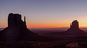
West and East Mitten Buttes
Buttes in Arizona, United States

Merrick Butte
Butte in Navajo County, Arizona

Spearhead Mesa
Mountain in Arizona, United States

Elephant Butte (Monument Valley)
Mountain in Arizona, United States

Cly Butte
Mountain in Arizona, United States

Castle Rock (San Juan County, Utah)
Mountain in Utah, United States

King-on-his-Throne
Mountain in Utah, USA

Stagecoach (San Juan County, Utah)