East Hertfordshire
Non-metropolitan district in EnglandEast Hertfordshire is one of ten local government districts in Hertfordshire, England. Its council is based in Hertford, the county town of Hertfordshire. The largest town in the district is Bishop's Stortford, and the other main towns are Ware, Buntingford and Sawbridgeworth. At the 2011 Census, the population of the district was 137,687. By area it is the largest of the ten local government districts in Hertfordshire. The district borders North Hertfordshire, Stevenage, Welwyn Hatfield and Broxbourne in Hertfordshire, and Epping Forest, Harlow and Uttlesford in Essex.
Read article


Top Questions
AI generatedMore questions
Nearby Places

Nasty, Hertfordshire
Hamlet in Hertfordshire, England

Puckeridge
Village in Hertfordshire, England
St Edmund's College, Ware
Private day and boarding school in Ware, Hertfordshire, England

Braughing
Village in Hertfordshire, England
Braughing (Roman town)
Standon Priory
Monastery in Essex, England

Great Munden
Village and civil parish in Hertfordshire, England
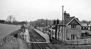
Braughing railway station
Disused railway station in Braughing, Hertfordshire