Map Graph
No coordinates found

Eastern United States

Geographic region

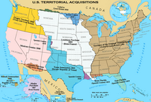
The Eastern United States, often abbreviated as simply the East, is a macroregion of the United States located to the east of the Mississippi River. It includes 17–26 states and Washington, D.C., the national capital.

Read article
File:U.S._Territorial_Acquisitions.pngFile:Top_of_Rock_Cropped.jpgFile:2009-09-18_3060x2040_chicago_skyline.jpgFile:The_Philadelphia_Skyline_at_Dusk.jpgFile:Jacksonville_at_Night_(39527326802).jpgFile:Uptown_Charlotte_2018_taking_by_DJI_Phantom_4_pro.jpgFile:Downtown_indy_from_parking_garage_zoom.JPGFile:WashMonument_WhiteHouse.jpgFile:Bostonstraight.jpgFile:DetroitSkyline.jpgFile:Memphis_skyline_from_the_air.jpgFile:LouisvilleNightSkyline2-small.jpgFile:Milwaukee_skyline.jpgFile:Baltimore_Harbor_from_rest.jpgFile:Midtownatlanta.jpgFile:Downtown-Raleigh-from-Western-Boulevard-Overpass-20081012.jpegFile:Miamiatnightpink.jpgFile:Virginia_Beach_from_Fishing_Pier.jpgFile:Minneapolis_Skyline_looking_south.jpgFile:TampaSkyline.jpgFile:Flats_-_1_(13966708395).jpgFile:LexingtonDowntown.JPGFile:Cincinnati_oh_skyline.jpgFile:Greensboro_Skyline.jpg
Top Questions
AI generated

List the top facts about Eastern United States

Summarize this article

What is the single most intriguing fact about Eastern United States?

Are there any controversies surrounding Eastern United States?

More questions