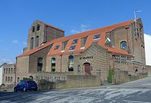
Elm Grove, Brighton
Area of Brighton and Hove, EnglandElm Grove is a mainly residential area of Brighton, part of the English coastal city of Brighton and Hove. The densely populated district lies on a steep hill northeast of the city centre and developed in the second half of the 19th century after the laying out of a major west–east road, also called Elm Grove. Terraced houses, small shops and architecturally impressive public buildings characterise the streetscape: within the area are a major hospital, two churches and a former board school, as well as Brighton's oldest council houses and an interwar council estate.
Read article
Top Questions
AI generatedMore questions
Nearby Places

Hanover, Brighton
Area of Brighton, England

St Martin's Church, Brighton
Church in Brighton, England
Prince of Wales Ground
Cricket ground in Brighton, England

Hartington Road Halt railway station
Former railway station in England

St Wilfrid's Church, Brighton
Church in Brighton and Hove , England

St Joseph's Church, Brighton
Church in Brighton and Hove , England

Percy and Wagner Almshouses
Historic site in East Sussex, United Kingdom

William Clarke Park
Public park in Brighton, England


