Enfield Lock
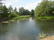
Human settlement in EnglandEnfield Lock is an area in the London Borough of Enfield, north London. It is approximately located east of the Hertford Road between Turkey Street and the Holmesdale Tunnel overpass, and extends to the River Lee Navigation, including Enfield Island Village. The locality gains its name from the lock on the River Lee Navigation. Today's Enfield Lock was rebuilt in 1922. The area forms part of the Lee Valley Park and the Enfield Lock Conservation Area. On its eastern boundary Enfield Lock has marshland formerly used as a testing site between the Royal Small Arms Factory and the Gunpowder Mills. Beyond this is the hamlet of Sewardstone and the boundary of Epping Forest. To the south is Brimsdown; to the north Waltham Cross; and to the west Bullsmoor and Freezywater. Enfield Lock forms part of the boundary of Greater London.
Read article
.jpg)

.jpg)
Top Questions
AI generatedMore questions
Nearby Places
Royal Small Arms Factory
Rifle factory in Enfield, London, 1816–1988

Enfield Lock railway station
National Rail station in London, England

Enfield Island Village
Housing development in London, England
Turkey Brook
River in the northern outskirts of London

Enfield Power Station
Gas-fired power station in England

Enfield Lock (lock)
Water navigational degice in a London borough
Aylward Academy
Academy in Enfield, Middlesex, England

Oasis Academy Enfield
Academy in Enfield Lock, Greater London, England