Enga Province
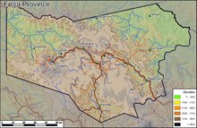
Province in Papua New GuineaEnga is one of the provinces in Papua New Guinea (PNG). Enga is geographically situated in the northern region of Papua New Guinea and was separated from the adjacent Western Highlands at the time of national independence in 1975. The majority ethnic group are Engans. Approximately 500,000 people live within the province, which has one spoken language in all five of its districts. A small minority of Engans' land on the eastern side of the region remained in the Western Highlands, their territory being accessible by road from Mount Hagen but not directly from elsewhere in Enga territory.
Read article
Top Questions
AI generatedMore questions


