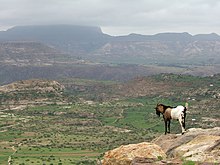
Ethiopian Highlands
Mountain range in northern EthiopiaThe Ethiopian Highlands is a rugged mass of mountains extending from Ethiopia to Eritrea in Northeast Africa. It forms the largest continuous area of its elevation in the continent, with little of its surface falling below 1,500 m (4,900 ft), while the summits reach heights of up to 4,550 m (14,930 ft). It is sometimes called the "Roof of Africa" due to its height and large area. It is the only country in the region with such a high elevated surface. This elevated surface is bisected diagonally by the Great East African Rift System which extends from Syria to Mozambique across the East African Lakes. Most of the Ethiopian Highlands are part of central and northern Ethiopia, with the Eritrean Highlands as its northernmost portion. The Ethiopia-Yemen Continental Flood Basalts are shared between the Horn of Africa and highlands of Upper Yemen along with the cultural, historical, and genetic ties of the two regions on opposite ends of the Red Sea.


