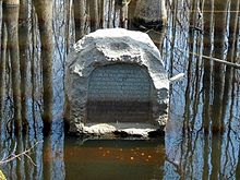
Fifth principal meridian
US survey lineThe Fifth Principal Meridian, also known as the "5th Principal Meridian" and "PM 05", is a principal meridian survey line used in the United States for land claims in the Public Land Survey System (PLSS). It was first surveyed in 1815. The meridian, a north-south line, starts from the old mouth of the Arkansas River and runs north. Another survey line related to it is the base line running west from the old mouth of the St. Francis River. These survey lines govern all land surveys in four states and a large portion of the land surveys for two more. Monuments have been erected where the two lines meet at 34°38′44″N 91°3′42″W, and the surveyors' skill has been commemorated at the Louisiana Purchase State Park in eastern Arkansas. The Fifth Principal Meridian is nearly coincident with 91° 3′ 42″ longitude west from the Greenwich meridian.


