Geography of Aruba
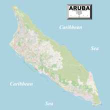
The geography of Aruba, located at the juncture of the South American and Caribbean tectonic plates, has been shaped by a complex interplay of geological processes. From its flat expanses to its rugged coastlines, Aruba's geography and geology reveal the island's geographical diversity and its underlying geological formations, offering a comprehensive understanding of Aruba's terrain and environmental dynamics of this Caribbean destination.
Read article
Top Questions
AI generatedMore questions
Nearby Places

Aruba
Dutch Caribbean island country

Hooiberg
Conical hill on Aruba

Frenchman's Pass

Jamanota
Aruba's highest natural point

Santa Cruz, Aruba
Town and region in Santa Cruz, Aruba

Spaans Lagoen
Protected area in Aruba

Barcadera
Port in Aruba

RECIP IV Power Station
Photovoltaic power plant in Oranjestad, Aruba


