Map Graph

Geography of Ecuador

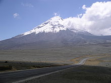
Ecuador is a country in western South America, bordering the Pacific Ocean at the Equator, for which the country is named. Ecuador encompasses a wide range of natural formations and climates, from the desert-like southern coast to the snowcapped peaks of the Andes mountain range to the plains of the Amazon Basin. Cotopaxi in Ecuador is one of the world's highest active volcanos. It also has a large series of rivers that follow the southern border and spill into the northwest area of Peru.

Read article
File:Ecuador_Blue_Marble.pngFile:Ec-map.pngFile:Ecuador_Topography.pngFile:Localisation_de_l'ile_de_Clipperton.pngFile:School_of_Hammerhead_sharks.jpgFile:Sphyrna_lewini_galapagos.jpgFile:Ecuador_aguablanca_sulfur_laguna.jpgFile:Gigantic_Turtle_on_the_Island_of_Santa_Cruz_in_the_Galapagos.JPGFile:Fresh_Water_Swimming_in_the_Galapagos_on_the_Island_of_Santa_Cruz.JPGFile:Imbabura_des_del_sud.JPGFile:Ecuador_Chimborazo_fromnorthwest.JPGFile:Andes_Mountains_South_America_Photograph_022.JPGFile:Ecuador_Pastazas_near_Banos.JPGFile:Koppen-Geiger_Map_ECU_present.svgFile:Ecuador_ParamosnearAmbato.JPG
Top Questions
AI generated

List the top facts about Geography of Ecuador

Summarize this article

What is the single most intriguing fact about Geography of Ecuador?

Are there any controversies surrounding Geography of Ecuador?

More questions