Map Graph
No coordinates found

Geography of Qatar

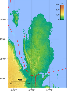
Qatar is a peninsula in the east of Arabia, bordering the Persian Gulf and Saudi Arabia in a strategic location near major petroleum and natural gas deposits. The State of Qatar occupies 11,571 km2 (4,468 sq mi) on a peninsula that extends about 160 km (99 mi) north into the Persian Gulf from the Arabian Peninsula.

Read article
File:QatarOMCmap.pngFile:Qatar_31_January_2003.jpgFile:Weather_station_in_Al_Kharrarah.jpgFile:Qatar_Topography.pngFile:Qatar,_Simaisma_(12),_desert.jpgFile:Rawdat_Jarrah_separating_Dukhan_Sabkha_from_Bay_of_Zekreet.jpgFile:Dunes_at_Khawr_al_Udayd_in_2004.jpgFile:Fossilized_dugong_bones_in_sabkha_in_southwest_Qatar.jpgFile:A_depression_(rawda)_near_Jebel_Jassasiya_in_northern_Qatar.jpgFile:Qatar,_Zekreet_(Bir_Zekrit)(8),_desert.jpgFile:Palm_tree_cluster_near_Umm_Bab_beach.jpgFile:A_mountain_goat_at_Haloul_Island.jpgFile:Nakhsh_mountain_in_Qatar.jpgFile:Hillock_at_northern_end_of_Al_Khor_Island.jpgFile:Water_Stress,_Top_Countries_(2020).svgFile:Qatar_sandstorm.JPG
Top Questions
AI generated

List the top facts about Geography of Qatar

Summarize this article

What is the single most intriguing fact about Geography of Qatar?

Are there any controversies surrounding Geography of Qatar?

More questions