Gilgit District
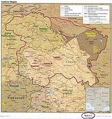
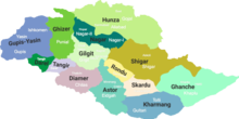
District of Gilgit-Baltistan in PakistanThe Gilgit District is one of the 14 districts of Pakistan-administered territory of Gilgit-Baltistan in the disputed Kashmir region. The headquarters of the district is the town of Gilgit. At the 1998 census, the Gilgit District had a population of 243,324. The district includes Gilgit, the Bagrot Valley, Juglot, Danyore, Sultanabad, Naltar Peak, and the Nomal Valley. The highest peak in the district is Distaghil Sar 7,885 metres (25,869 ft), which is the seventh-highest peak in Pakistan and 19th highest in the world.
Read article
Top Questions
AI generatedMore questions
Nearby Places

Hunza River
River in Pakistan

Minawar
Village in Gilgit–Baltistan, Pakistan

Jalalabad, Gilgit
Place in Pakistan

Chinese Cemetery (Danyor)
Resting place for deceased Chinese workers in Pakistan

Danyor
City in Gilgit-Baltistan, Pakistan

Danyor Suspension Bridge
Bridge in Pakistan
Batkor
Village in Gilgit-Baltistan, Pakistan
Sultanabad, Gilgit-Baltistan
Village in Gilgit-Baltistan, Pakistan


