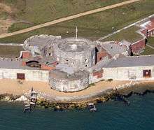
Hurst Spit
Shingle bank near Keyhaven, EnglandHurst Spit is a one-mile-long (1.6 km) shingle bank near the village of Keyhaven, at the western end of the Solent, on the south coast of England. The spit shelters an area of saltmarsh and mudflats known as Keyhaven and Pennington marshes. At the end of the spit is Hurst Castle, an artillery fortress originally built on the orders of King Henry VIII, and much enlarged in the 19th century. Hurst Point Lighthouse was built on the end of Hurst Spit in the 1860s.
Read article
Top Questions
AI generatedMore questions
Nearby Places

Hurst Castle
Device Fort in Hampshire, England

Fort Albert
Tower fort on the Isle of Wight, England
Fort Victoria, Isle of Wight
Victorian former military fort near Yarmouth, Isle of Wight in England

Keyhaven
Hamlet in Hampshire, England

Archaeology Discover Centre
Museum in Fort Victoria,Isle of Wight, England

Warden Point Battery
Artillery battery in Totland, Isle of Wight, England

Hurst Point Lighthouse
Lighthouse in Hampshire, England

Cliff End Battery


