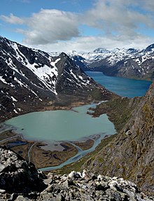
Jotunheimen National Park
National parkJotunheimen National Park is a national park in Norway, recognized as one of the country's premier hiking and fishing regions. The national park covers 1,151 square kilometres (444 sq mi) and is part of the larger area Jotunheimen. More than 250 peaks rise above an elevation of 1,900 metres (6,200 ft), including Northern Europe's three highest peaks: Galdhøpiggen at 2,469 metres (8,100 ft), Glittertind at 2,452 metres (8,045 ft) and Store Skagastølstind at 2,405 metres (7,890 ft).
Read article
Top Questions
AI generatedMore questions
Nearby Places
Langvasshøe
Mountain in Innlandet, Norway
Semelholstinden
Mountain in Innlandet, Norway

Semeltinden
Mountain in Innlandet, Norway

Skarddalstinden
Mountain in Innlandet, Norway

Skarddalseggje
Mountain in Innlandet, Norway

Søre Hellstugutinden
Mountain in Innlandet, Norway

Visbreatinden
Mountain in Innlandet, Norway

Store Rauddalseggje
Mountain in Norway


