Kings Langley
Village and civil parish in Hertfordshire, EnglandKings Langley is a village, former manor and civil parish in Hertfordshire, England, 23.5 miles north-west of London and to the south of the Chiltern Hills. It now forms part of the London commuter belt. The village is divided between two local government districts by the River Gade with the larger western portion in the Borough of Dacorum and smaller part, to the east of the river, in Three Rivers District. It was the location of Kings Langley Palace and the associated King's Langley Priory, of which few traces survive.
Read article


.jpg)


Top Questions
AI generatedMore questions
Nearby Places
Kings Langley School
Academy in Kings Langley, Hertfordshire, England

Nash Mill
Kings Langley F.C.
Association football club in England

Rudolf Steiner School Kings Langley
Defunct school in Hertfordshire, England

Kings Langley Palace
Palace in Hertfordshire, England

King's Langley Priory
Former priory in Herefordshire, England
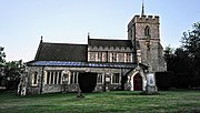
All Saints' Church, Kings Langley
Church in Hertfordshire, England
Langley House
House in Kings Langley, Hertfordshire, England