Geography of the United Kingdom
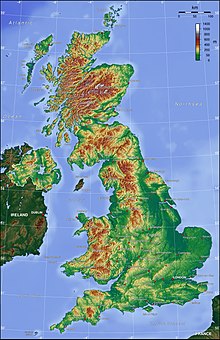
The United Kingdom is a sovereign state located off the north-western coast of continental Europe. The United Kingdom is made up of four countries – England, Scotland, Wales and Northern Ireland. With a total area of approximately 244,376 square kilometres (94,354 sq mi), the UK occupies the major part of the British Isles archipelago and includes the island of Great Britain, the north-eastern one-sixth of the island of Ireland and many smaller surrounding islands. It is the world's 7th largest island country. The mainland areas lie between latitudes 49°N and 59°N, and longitudes 8°W to 2°E. The Royal Observatory, Greenwich, in south-east London, is the defining point of the Prime Meridian.
Read article
Top Questions
AI generatedMore questions
Nearby Places

Wolfhole Crag
Mountain in northwest England

White Hill (Forest of Bowland)
Hill in northern England

Slaidburn
Village in Lancashire, England

Stocks Reservoir
Reservoir in Lancashire, England

Brennand Farm
British geographical location

St Andrew's Church, Slaidburn
Church in Lancashire, England

King's House, Slaidburn
Historic site in Slaidburn

Lancashire Witches Walk
Long-distance footpath in Lancashire, England


