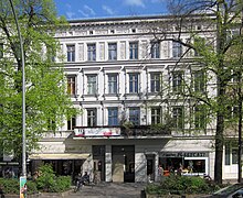
Mehringdamm
Street in southern Kreuzberg, BerlinThe Mehringdamm is a street in southern Kreuzberg, Berlin. In the north it starts at Mehringbrücke and ends - with its southernmost houses already belonging to Tempelhof locality - on Platz der Luftbrücke. It is the historical southbound Berlin-Halle highway, now forming the federal route 96. The main junction of Mehringdamm is with the 19th-century ring road around Berlin's inner city, named Yorckstraße west, and Gneisenaustraße east of Mehringdamm.
Read article
Top Questions
AI generatedMore questions
Nearby Places

Kreuzberg
District of Berlin, Germany

Viktoriapark
Park in Berlin

Gneisenaustraße (Berlin U-Bahn)
Station of the Berlin U-Bahn

Mehringdamm (Berlin U-Bahn)
Station of the Berlin U-Bahn

Schwules Museum
Museum of LGBT+ history in Berlin

Amerika-Gedenkbibliothek
Public library in Berlin

Prussian National Monument for the Liberation Wars
Monument in Berlin

Mehringhof
German building complex for alternative activities


