Middle Level Navigations
Waterway network in eastern EnglandThe Middle Level Navigations are a network of waterways in England, primarily used for land drainage, which lie in The Fens between the Rivers Nene and Great Ouse, and between the cities of Peterborough and Cambridge. Most of the area through which they run is at or below sea level, and attempts to protect it from inundation have been carried out since 1480. The Middle Level was given its name by the Dutch Engineer Cornelius Vermuyden in 1642, who subsequently constructed several drainage channels to make the area suitable for agriculture. Water levels were always managed to allow navigation, and Commissioners were established in 1754 to maintain the waterways and collect tolls from commercial traffic.
Read article


Top Questions
AI generatedMore questions
Nearby Places
Connington South rail crash
1967 deliberate train wreck in Huntingdonshire, England

RAF Glatton
Former RAF station in Cambridgeshire, England
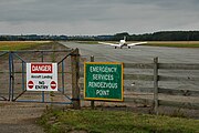
Peterborough Business Airport
Airport in Peterborough, England
Holme railway station (Cambridgeshire)
Former railway station in Cambridgeshire, England
Battle of the Holme
Battle in East Anglia between Wessex and Kent against the Danelaw and East Anglian Danes

All Saints Church, Conington
Church in Cambridgeshire, England

Conington Castle
16th-century house in Huntingdonshire, England

Admiral Wells
Historic pub in Holme, England