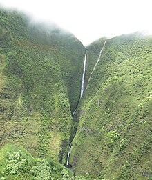
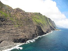
Molokaʻi
Fifth largest island in HawaiiMolokaʻi or Molokai is the fifth most populated of the eight major islands that make up the Hawaiian Islands archipelago in the middle of the Pacific Ocean. It is 38 by 10 miles at its greatest length and width with a usable land area of 260 sq mi (673.40 km2), making it the fifth-largest in size of the main Hawaiian Islands and the 27th largest island in the United States. It lies southeast of Oʻahu across the 25 mi (40 km) wide Kaʻiwi Channel and north of Lānaʻi, separated from it by the Kalohi Channel.
Read article
Top Questions
AI generatedMore questions
Nearby Places

Kaunakakai, Hawaii
Census-designated place in Hawaii, United States

Kualapuʻu, Hawaii
Census-designated place in Hawaii, United States

Kalaupapa, Hawaii
Unincorporated community in the state of Hawaii, United States

Kalaupapa National Historical Park
National Historical Park of the United States
Palaʻau State Park
State park in Hawaii, United States
Molokaʻi High School
Public high school
KIOM-LP
Radio station in Kaunakakai, Hawaii

Kauhakō Crater


