Mount Mitchell
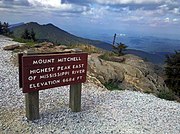
Highest mountain in North Carolina, United StatesMount Mitchell is the highest peak of the Appalachian Mountains and the highest peak in mainland North America east of the Mississippi River. It is located near Burnsville in Yancey County, North Carolina in the Black Mountain subrange of the Appalachians about 19 miles (31 km) northeast of Asheville. It is protected by Mount Mitchell State Park and surrounded by the Pisgah National Forest. Mount Mitchell's elevation is 6,684 feet (2,037 m) above sea level. Mount Mitchell is ranked 31st by topographic isolation.
Read article


Top Questions
AI generatedMore questions
Nearby Places

Blue Ridge Mountains
Mountain range in the Eastern U.S.
Mount Mitchell State Park
State park in Yancey County, North Carolina, United States

Black Mountains (North Carolina)
Mountain range in the United States
WNCW
Adult album alternative public radio station in Spindale, North Carolina, United States

Mount Craig (North Carolina)
Mountain in North Carolina, United States

Buck Creek Gap
Mountain pass along the Blue Ridge Mountains
Camp Celo
Summer camp in North Carolina

Busick, North Carolina
Populated place in North Carolina, United States