Mount Rainier National Park
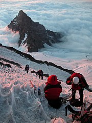
National park in Washington, United StatesMount Rainier National Park is a national park of the United States located in southeast Pierce County and northeast Lewis County in Washington state. The park was established on March 2, 1899, as the fourth national park in the United States, preserving 236,381 acres including all of Mount Rainier, a 14,410-foot (4,390 m) stratovolcano. The mountain rises abruptly from the surrounding land with elevations in the park ranging from 1,600 feet to over 14,000 feet (490–4,300 m). The highest point in the Cascade Range, Mount Rainier is surrounded by valleys, waterfalls, subalpine meadows, and 91,000 acres of old-growth forest. More than 25 glaciers descend the flanks of the volcano, which is often shrouded in clouds that dump enormous amounts of rain and snow.
Read article


.jpg)


Top Questions
AI generatedMore questions
Nearby Places

Cascade Range
Mountain range in western North America

Little Tahoma Peak
Subpeak of Mount Rainier

Emmons Glacier
Glacier in Washington, United States
Ingraham Glacier
Glacier in Washington, United States

Camp Muir
United States historic place

List of mountain peaks of Washington

Mount Rainier
Stratovolcano in the U.S. state of Washington

Willis Wall
Cliff in Pierce County, Washington, USA