Parish of Manangle
Cadastral in New South Wales, AustraliaManangle Parish, Cumberland is one of the 57 parishes of Cumberland County, New South Wales, a cadastral unit for use on land titles. Its eastern boundary is the Georges River, and western boundary the Nepean River. It includes the southern Sydney suburbs of Menangle Park, Gilead, Rosemeadow and part of Glen Alpine. Major roads in the area include the South Western Freeway, Menangle Road and Appin Road.
Read article

Top Questions
AI generatedMore questions
Nearby Places

St Helens Park, New South Wales
Suburb of Campbelltown, New South Wales, Australia

Rosemeadow, New South Wales
Suburb of Sydney, New South Wales, Australia
Gilead, New South Wales
Suburb of Sydney, New South Wales, Australia
Broughton Anglican College
School in Australia
John Therry Catholic High School
School in Australia
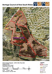
Sugarloaf Farm
Historic site in New South Wales, Australia

Denfield
Historic site in New South Wales, Australia

Beulah, Gilead
Historic site in New South Wales, Australia