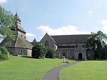
Pembridge
Village and civil parish in Herefordshire, EnglandPembridge is a village and civil parish in the Arrow valley in Herefordshire, England. The village is on the A44 road about 6 miles (10 km) east of Kington and 7 miles (11 km) west of Leominster. The civil parish includes the hamlets of Bearwood, Lower Bearwood, Lower Broxwood, Marston, Moorcot and Weston. The 2011 Census recorded the parish population as 1,056.
Read article
Top Questions
AI generatedMore questions
Nearby Places
Shobdon Airfield
Airport in Herefordshire, England

Shobdon
Village in Herefordshire, England

Eardisland
Village in Herefordshire, England

Burton Court, Eardisland
Grade II* listed country manor house in the Parish of Eardisland, England
Marston Halt railway station
Former railway station in Herefordshire, England

Pembridge railway station
Former railway station in Herefordshire, England

Staunton on Arrow
Village in Herefordshire, England

St Mary's Church, Pembridge
Church in Herefordshire, England


