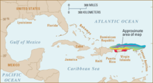
Puerto Rico Trench
Oceanic trench on a transform boundary between the Caribbean and North American platesThe Puerto Rico Trench is located on the boundary between the North Atlantic Ocean and Caribbean Sea, parallel to and north of Puerto Rico, where the oceanic trench reaches the deepest points in the Atlantic Ocean. The trench is associated with a complex transition from the Lesser Antilles frontal subduction zone between the South American plate and Caribbean plate to the oblique subduction zone and the strike-slip transform fault zone between the North American plate and Caribbean plate, which extends from the Puerto Rico Trench at the Puerto Rico–Virgin Islands microplate through the Cayman Trough at the Gonâve microplate to the Middle America Trench at the Cocos plate.
Read article
Top Questions
AI generatedMore questions


