Map Graph

Red Sea

Arm of the Indian Ocean between Asia and Africa

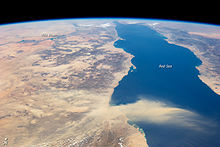
The Red Sea is a sea inlet of the Indian Ocean, lying between Africa and Asia. Its connection to the ocean is in the south, through the Bab-el-Mandeb Strait and the Gulf of Aden. To its north lie the Sinai Peninsula, the Gulf of Aqaba, and the Gulf of Suez—leading to the Suez Canal. It is underlain by the Red Sea Rift, which is part of the Great Rift Valley.

Read article
File:Red_Sea_topographic_map-en.jpgFile:Tihama_on_the_Red_Sea_near_Khaukha,_Yemen.jpgFile:Empty_Coast_in_Farasan_Island.jpgFile:C+B-Ship-Fig1-HatshepsuSailingBoat.PNGFile:Periplous_of_the_Erythraean_Sea.svgFile:ISS036-E-011050.jpgFile:Dust_red_sea.jpgFile:Red_sea_stony_beach_taba_egypt.jpgFile:Hawksbill_turtle_at_Elphinstone_Reef,_Red_Sea,_Egypt_(35150034493).jpgFile:Nudibranch_egg_ribbon_at_Shaab_Mahmoud.JPGFile:Red_sea_coral_reef.jpgFile:Red_Sea_map.svg
Top Questions
AI generated

List the top facts about Red Sea

Summarize this article

What is the single most intriguing fact about Red Sea?

Are there any controversies surrounding Red Sea?

More questions