Reigate and Banstead
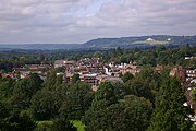
Borough and non-metropolitan district in EnglandReigate and Banstead is a local government district with borough status in Surrey, England. Its council is based in Reigate and the borough also includes the towns of Banstead, Horley and Redhill. Parts of the borough are within the Surrey Hills, a designated Area of Outstanding Natural Beauty. Northern parts of the borough, including Banstead, lie inside the M25 motorway which encircles London.
Read article


Top Questions
AI generatedMore questions
Nearby Places

Redhill railway station
Railway station in Surrey, England
East Surrey
Future unitary authority area and borough in England
St Bede's School
Secondary school in Surrey, England

Gatton, Surrey
Human settlement in England

SES Water
British water supply company
Carrington School
Academy in Redhill, Surrey, England

Redhill Tunnel
Railway tunnel in Sussex, England

Nutfield Marshes