River Lagan
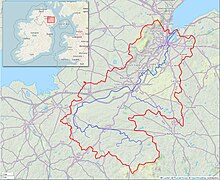
River in Northern IrelandThe River Lagan is a major river in Northern Ireland which runs 53.5 mi (86.1 km) from the Slieve Croob mountain in County Down to Belfast where it enters Belfast Lough, an inlet of the Irish Sea. The Lagan forms much of the border between County Antrim and County Down in the east of Ulster. It rises as a stream near to the summit of Slieve Croob. It runs to Belfast through Dromara, Donaghcloney and Dromore. On the lower slopes of the mountain, it combines with a branch from Legananny Mountain, just opposite Slieve Croob. The river then turns east to Magheralin into a broad plain between the plateaus of Antrim and Down.
Read article
Top Questions
AI generatedMore questions
Nearby Places

Carrickfergus
Town in County Antrim, Northern Ireland

Carrickfergus Castle
Norman Castle on the island of Ireland

Belfast Lough
Large, intertidal sea inlet on the east coast of Northern Ireland

Carrickfergus Waterfront
Area of Carrickfergus, Belfast Lough, UK

Battle of Carrickfergus (1597)
Battle during the Nine Years War
Carrickfergus Sailing Club

Rockport School
Independent day and boarding school near Holywood, Northern Ireland

Carrickfergus Lifeboat Station
Former RNLI lifeboat station in County Antrim, Northern Ireland


