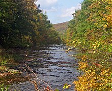
Rondout Creek
River in New York, United StatesRondout Creek is a 63.3-mile-long (101.9 km) tributary of the Hudson River in Ulster and Sullivan counties, New York, United States. It rises on Rocky Mountain in the eastern Catskills, flows south into Rondout Reservoir, part of New York City's water supply network, then into the valley between the Catskills and the Shawangunk Ridge, where it goes over High Falls and finally out to the Hudson at Kingston, receiving along the way the Wallkill River.
Read article
Top Questions
AI generatedMore questions
Nearby Places
Kingston Point station

Rhinecliff station
Amtrak rail station in Rhinebeck, New York

O'Brien General Store and Post Office
Historic commercial building in New York, United States

Rondout Light
Lighthouse

Morton Memorial Library (Rhinecliff, New York)
United States historic place

Free Church Parsonage
United States historic place

Rhinecliff Hotel
United States historic place
K. Whittelsey
United States historic place


