Roztocze
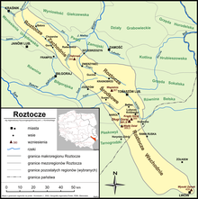
Range of hills in Poland and UkraineRoztocze is a range of hills in southeastern Poland and western Ukraine which rises from the Lublin Upland and extends southeastward through Solska Forest and across the border into Ukrainian Podolia. Low and rolling, the range is approximately 180 km long and 14 km wide. Its highest peak within Poland is Wielki Dział at 390 meters, while in Ukraine it is Vysokyi Zamok at 409 m. In Poland Roztocze lies in the Lublin and Podkarpackie voivodships, while the portion in Ukraine extends all the way to the outskirts of Lviv. In 2011 UNESCO established the Roztochia Biosphere Reserve. The Polish portion of the range makes up the Roztocze National Park.
Read article
Top Questions
AI generatedMore questions
Nearby Places
Grabowica, Lublin Voivodeship
Village in Lublin Voivodeship, Poland
Kunki, Lublin Voivodeship
Village in Lublin Voivodeship, Poland
Łasochy
Village in Lublin Voivodeship, Poland
Łuszczacz
Village in Lublin Voivodeship, Poland
Róża, Lublin Voivodeship
Village in Lublin Voivodeship, Poland
Zawadki, Tomaszów Lubelski County
Village in Lublin Voivodeship, Poland
Ulów, Lublin Voivodeship
Village in Lublin Voivodeship, Poland
Zielone, Lublin Voivodeship
Village in Lublin Voivodeship, Poland


