Scaleby
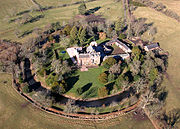
Village in Cumbria, EnglandScaleby is a village and civil parish in the Cumberland district, in the ceremonial of Cumbria. It is bounded on the north by Kirklinton and Irthington; whilst to the south lie Stanwix and Crosby-on-Eden. Scaleby is located six miles north-east of the city of Carlisle, and has a population of 349, falling slightly to 346 at the 2011 Census. Scaleby is located close to the M6 motorway making it relatively accessible to anyone interested in its two main attractions; Scaleby Castle and the Church of All Saints, the former having many links with notable names in history. The parish includes the hamlets of Barclose, Longpark and Scalebyhill. From 1974 to 2023 it was in Carlisle district.
Read article


Top Questions
AI generatedMore questions
Nearby Places

Stanwix Rural
Civil parish in Cumbria, England
Skitby
Hamlet in Cumbria, England

Smithfield, Cumbria
Village in Cumbria, England
Barclose
Hamlet in Cumberland, England

Walby
Hamlet in Cumbria, England
Scaleby Castle
Castle in Cumbria, England

Milecastle 61
Milecastle 62
Milecastle on Hadrian's Wall in England