Sia La
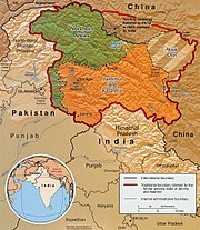
Mountain pass in LadakhSia La is a mountain pass situated on Saltoro Ridge some 60 km (37 mi) north-northwest of map point NJ9842 which defined the end of the 1972 Line of Control between India and Pakistan as part of the Simla Agreement. Sia La is under Indian control and sits near the Line of Actual Control between India and China and is immediately northwest of the upper part of the vast Siachen Glacier, connecting that glacier to the Pakistani-controlled Kondus Glacier and valley to the west.
Read article


Top Questions
AI generatedMore questions