Slaugham
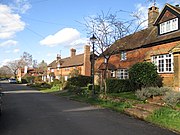
Village and parish in West Sussex, EnglandSlaugham is a village and civil parish in the Mid Sussex District of West Sussex, England. It is located 7 miles (11 km) to the south of Crawley, on the A23 road to Brighton. The civil parish covers an area of 2,432 hectares. At the 2001 census it had a population of 2,226 persons of whom 1,174 were economically active. At the 2011 Census the parish included the villages of Handcross and Warninglid and had a population of 2,769. In addition the parish contains the settlement of Pease Pottage.
Read article


Top Questions
AI generatedMore questions
Nearby Places
Brighton College Prep Handcross
School in Handcross, West Sussex, England

Staplefield
Village in West Sussex, England

Handcross
Village in West Sussex, England
Warninglid
Village in West Sussex, England

St Mary's Church, Slaugham
Church in West Sussex , England

Nymans
Grade II* garden in West Sussex, England

Cow Wood and Harry's Wood
Site of special scientific interest in West Sussex, England
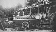
Handcross Hill bus crash
1906 bus crash in England