Springbourne
Suburb of Bournemouth, EnglandSpringbourne is a suburb of Bournemouth in Dorset, England. It occupies the north-east part of the main built-up area, north of Boscombe. Its formal boundaries are Northcote Road to the west, the Wessex Way (A338) to the north, Ashley Road to the east, and the railway line to the south.
Read article


Top Questions
AI generatedMore questions
Nearby Places

Boscombe
Suburb of Bournemouth, England

Dean Court
Football stadium in Bournemouth, England

O2 Academy Bournemouth
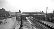
Boscombe railway station
Disused railway station in Dorset, England

Langtry Manor
Country house hotel in Dorset, England
Bournemouth East railway station (1870–1885)
Disused railway station in Dorset, England

Holdenhurst Road drill hall, Bournemouth
Military building in Bournemouth, England

St Clement's Church, Bournemouth
Church in Dorset, England