St George Hanover Square
Former civil parish in London, EnglandSt George Hanover Square was a civil parish in the metropolitan area of London, England. The creation of the parish accompanied the building of the Church of St George's, Hanover Square, constructed by the Commission for Building Fifty New Churches to meet the demands of the growing population. The parish was formed in 1724 from part of the ancient parish of St Martin in the Fields in the Liberty of Westminster and county of Middlesex. It included some of the most fashionable areas of the West End, including Belgravia and Mayfair. Civil parish administration, known as a select vestry, was dominated by members of the British nobility until the parish adopted the Vestries Act 1831. The vestry was reformed again in 1855 by the Metropolis Management Act. In 1889 the parish became part of the County of London and the vestry was abolished in 1900, replaced by Westminster City Council. The parish continued to have nominal existence until 1922. As created, it was a parish for both church and civil purposes, but the boundaries of the ecclesiastical parish were adjusted in 1830, 1835 and 1865.
Read article


Top Questions
AI generatedMore questions
Nearby Places

Sotheby's
International auction house
Kleinwort Benson
Investment bank in the UK
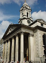
St George's, Hanover Square
Church in London, England

Embassy of Mexico, London
Diplomatic mission

Hibiscus (restaurant)
Restaurant in London
Hanover Gallery

Maddox Street
Street in Mayfair, London
Humo (restaurant)
Restaurant in London, United Kingdom