Sundridge with Ide Hill
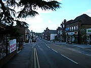
Civil parish in Kent, EnglandSundridge and Ide Hill is a civil parish in the Sevenoaks District of Kent, England. It is located in the Darenth valley and lies between Sevenoaks and Westerham. The parish contains the villages of Sundridge and Ide Hill and the hamlet of Goathurst Common. It lies within the Kent Downs Area of Outstanding Natural Beauty and within London's Metropolitan Green Belt. It is approximately 21 miles south of London.
Read article


Top Questions
AI generatedMore questions
Nearby Places

Marsh Green, Kent
Hamlet in Kent, United Kingdom

Cowden
Village in Kent, England

Hever railway station
Railway station in Kent, England

Markbeech
Village in Kent, England
London to Lewes Way
Roman road in England

Queen's Arms, Cowden Pound
Public house in Cowden, Kent

Cowden Pound Pastures
Protected area in Kent, England

St Mary Magdalene, Cowden
Church in England, England