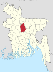
Tangail District
District in Dhaka Division, BangladeshTangail District is a district (zila) in the central region of Bangladesh. In 1969, Tangail mahakuma was separated from the Mymensingh district, and a district of the same name as the mahakuma's was created. The district consists of 237 square kilometers of the prior mahakuma and 3,177 square kilometers of land acquired from Mymensingh district. It is the largest district of Dhaka Division by area and second largest by population. The population of Tangail zila is about 4 million and its area is 3,414.28 square kilometres (1,318.26 sq mi). The main city of the district is Tangail. It is surrounded by Jamalpur District on the north, Dhaka and Manikganj Districts on the south, Mymensingh and Gazipur on the east, and Sirajganj on the west.
Read article
Top Questions
AI generatedMore questions
Nearby Places
Gharinda Union
Place in Dhaka Division, Bangladesh
Fulki Union
Place in Dhaka Division, Bangladesh
Kaoaljani Union
Place in Dhaka Division, Bangladesh
Balla Union
Place in Dhaka Division, Bangladesh
Kok Dohora Union
Place in Dhaka Division, Bangladesh
Nagbari Union
Place in Dhaka Division, Bangladesh
Paikara Union
Place in Dhaka Division, Bangladesh
Shahadebpur Union
Place in Dhaka Division, Bangladesh


