Thorne and Hatfield Moors
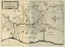
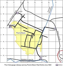
Lowland raised peat bog in EnglandThorne and Hatfield Moors form the largest area of lowland raised peat bog in the United Kingdom. They are situated in South Yorkshire, to the north-east and east of Doncaster near the town of Thorne, and are part of Hatfield Chase. They had been used for small-scale extraction of peat for fuel from medieval times, and probably much earlier, but commercial extraction of the peat for animal bedding began in the 1880s. The peat was cut on the moors and, once it had dried, transported to several works on 3 ft narrow gauge tramways, always called trams locally. The wagons were pulled by horses to works at Creyke's Siding, Moorends, Medge Hall, Swinefleet and Hatfield. There was also a network of canals supplying the Moorends Works.
Read article
Top Questions
AI generatedMore questions
Nearby Places

Moorends
Village in South Yorkshire, England

Club Thorne Colliery F.C.
Association football club in England

Maud's Bridge railway station
Former railway station in South Yorkshire, England

Humberhead Levels
National character area in England

Trinity Academy, Thorne
Academy in Thorne, England

Thorne Colliery
Former coal mine in South Yorkshire, England

Crowle Peatland Railway
Railway museum in Crowle, England

Swinefleet Warping Drain
Artificial waterway in the East Riding of Yorkshire, England


