Trebarwith Strand
Section of coastline in Northern Cornwall, UKTrebarwith Strand is a section of coastline located near the coastal settlement of Trebarwith on the north coast of Cornwall, Britain, UK, 2+1⁄2 miles (4.0 km) south of Tintagel. It has 800m of sandy beach contained by cliffs in which natural caves are found. The beach can only be accessed at low tide. The strand was once used to land ships to export slate from the nearby quarries while sand from the beach was used for agricultural purposes. The view from the beach is dominated by rocks 300m offshore known as Gull Rock or Otterham Rocks.
Read article


Top Questions
AI generatedMore questions
Nearby Places
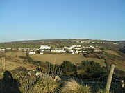
Treknow
Human settlement in England

HMS Vulture II (Treligga Aerodrome)
Treven

Lambshouse and Gull Point Quarry
Two disused slate quarries in Cornwall, England
Bagalow Quarry
Disused quarry in Cornwall, England

Lanterdan Quarry
Disused slate quarry in Cornwall, England
Penhallick Wharf

West Quarry
Disused slate quarry