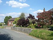
Walgherton
Human settlement in EnglandWalgherton is a village and civil parish in the unitary authority of Cheshire East and the ceremonial county of Cheshire, England. The village lies at SJ697489 by the junction of the A51 and B5071 roads, 3½ miles to the south east of Nantwich and 4½ miles to the south of Crewe. The civil parish also includes the small settlement of Hussey's Nook. The total population is just under 130 people. Sand has been extracted at Hough Mill Quarry. The remainder of the parish is predominantly agricultural. Nearby villages include Hatherton, Stapeley and Wybunbury.
Read article


Top Questions
AI generatedMore questions
Nearby Places

Hatherton, Cheshire
Hamlet and civil parish, Cheshire, England

Stapeley
Hamlet in Cheshire, England

Wybunbury
Village in Cheshire, England

Doddington, Cheshire
Former civil parish in Cheshire, England
Lea, Cheshire
Human settlement in England

St Chad's Church, Wybunbury
Church in Cheshire, England

Delves Hall
Historic site

Wybunbury Moss
British nature reserve