Lake Winnebago
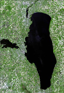
Lake in WisconsinLake Winnebago is a shallow freshwater lake in the north central United States, located in east central Wisconsin. At 137,700 acres (55,700 ha), it is the largest lake entirely within the state, covering an area of about 30 miles (48 km) by 10 miles (16 km) with 88 miles (142 km) of shoreline, an average depth of 15.5 feet (4.7 m), and a maximum depth of 21 feet (6.4 m). It has many shallow reefs along the west shore and a drop-off type shoreline on the east. There are several islands along the west shore.
Read article
Top Questions
AI generatedMore questions
Nearby Places

Asylum Light
Lighthouse

Rockwell Light
Lighthouse

WOSH
Radio station in Oshkosh, Wisconsin

Richard Guenther House
Historic house in Wisconsin, United States

Quinney, Wisconsin
Unincorporated community in Wisconsin, United States

First Methodist Church (Oshkosh, Wisconsin)
Historic church in Wisconsin, United States

Oshkosh Arena
Small arena in Oshkosh, Wisconsin

Menominee Park Zoo
Zoo in Wisconsin, United States


