Yellowstone River
River in the western United StatesThe Yellowstone River is a tributary of the Missouri River, approximately 671 miles (1,080 km) long, in the Western United States. Considered the principal tributary of the upper Missouri, via its own tributaries it drains an area with headwaters across the mountains and high plains of southern Montana and northern Wyoming, and stretching east from the Rocky Mountains in the vicinity of Yellowstone National Park. It flows northeast to its confluence with the Missouri River on the North Dakota side of the border, about 25 miles (40 km) west of Williston.
Read article


Top Questions
AI generatedMore questions
Nearby Places
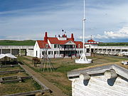
Fort Union Trading Post National Historic Site
National Historic Site of the United States in North Dakota

Fort Buford
United States historic place

Missouri-Yellowstone Confluence Interpretive Center
Museum in North Dakota, United States
Buford, North Dakota
Unincorporated community in North Dakota, United States

Mondak, Montana
Ghost town in Montana, United States
Fort Henry (North Dakota)
19th century fort on the Missouri River in the USA
Java, Montana
Ghost town in Richland County, Montana, United States
Nohly, Montana
Place in Montana, United States