Fichier:Dokkadeltaet_nord_i_Randsfjorden.jpg
De Wikipedia, l'encyclopédie encyclopedia
Fichier d’origine (5 184 × 3 456 pixels, taille du fichier : 5,7 Mio, type MIME : image/jpeg)
Ce fichier et sa description proviennent de Wikimedia Commons.
Description
| DescriptionDokkadeltaet nord i Randsfjorden.jpg |
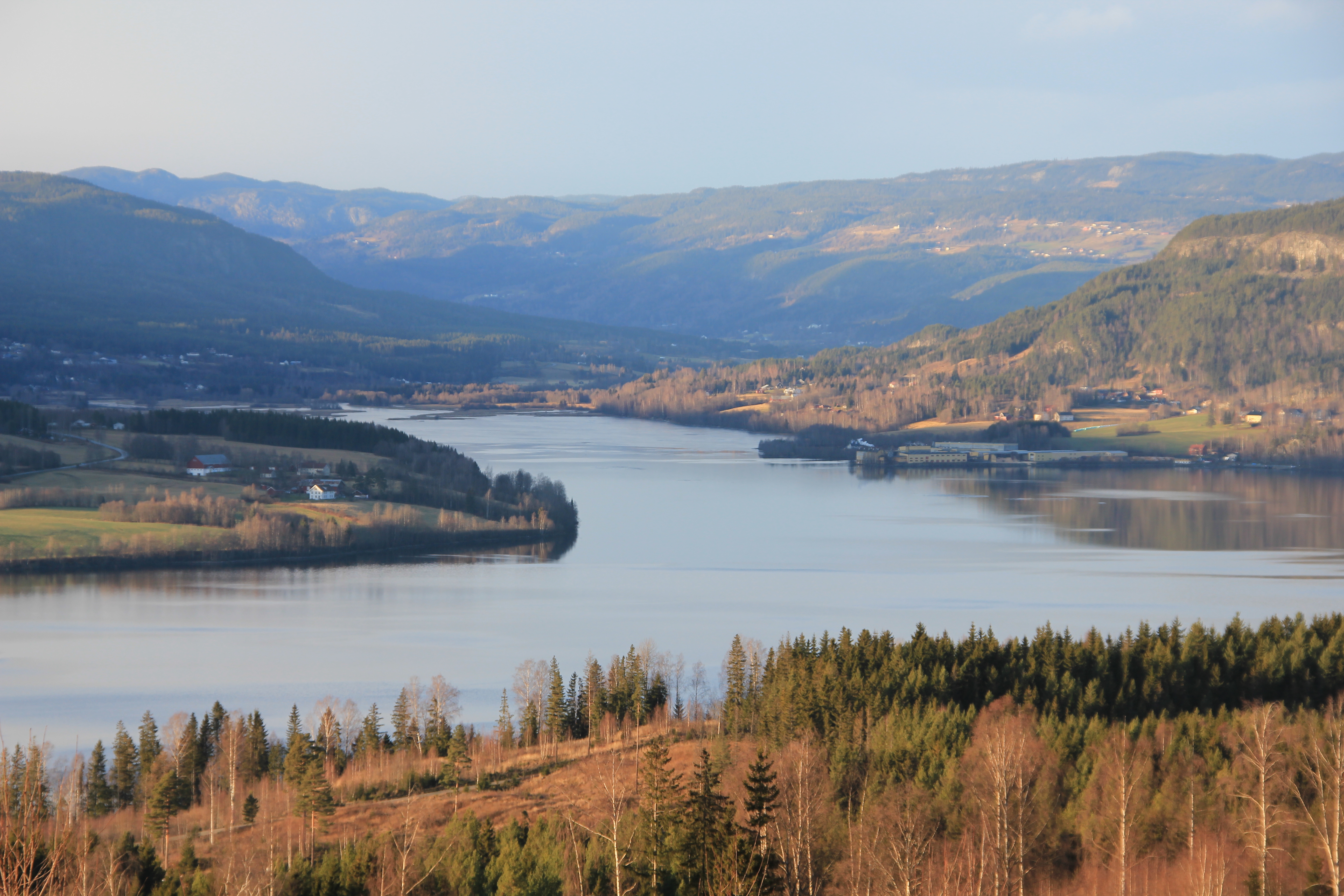
English: The northern end of Lake Randsfjorden in Oppland, Norway. The wetlands of the Dokka Delta is situated here where the river meats the lake.
Wisit the website of Dokkadeltaet National Wetland Center: http://www.dokkadelta.com/en/home/ "North of Oslo, west of Lillehammer and south of the highest mountains in Norway, Jotunheimen, water drains through mires, creeks and rivers into the ramsar site and nature reserve, Dokkadelta. The water from the alpine mountain region Synnfjell runs through the protected river Etna and through the river Dokka, passing several aqua power stations, into the fourth biggest lake of Norway, Randsfjord. Wetlands, creeks, rivers, forest and vast alpine mountains invite to experience the landscape of the municipalities Northern Land, Southern Land and Etnedal in the county of Oppland. Dokkadelta National Wetland Centre has got the task to develop this compact ecosystem for experiencing the strong bonds to nature in the culture of this region. But also protecting the biological diversity of this typical nordic wetland ecosystem for further generations. Nature, where the black throated diver calls on the foggy lake at dawn, and the capercaillie play games on the mires at spring. Where pike and trout grow to capital size, moose is resting in the meadows and the trumpet of cranes sounds through the valley. Where the full moon paints the winter forest in silver blue and ski trails wind through the mountains of silence. Where beaver and men work in the forest and river shells tell their stories of the century. An ecosystem for knowledge and experiences. We wish you welcome to visit our region. On a journey to our birds, our animals, our fish, our plants, our insects and us, the people of Land and Etnedal. For experiencing fjell, rivers or taiga forests. For the adventure of dog sledding, bird watching, canoeing, hiking, cycling, fishing, hunting, picking berries, backcountry skiing or wilderness camping. Or for sensing the nordic nature on a chair of experiences? Novalis wrote: "If you hear the butterfly laugh, you know how a cloud smells." Welcome, Dokkadeltaet National Wetland Center." Wisit the website of Dokkadeltaet National Wetland Center: http://www.dokkadelta.com/en/home/ |
| Date | |
| Source | Travail personnel |
| Auteur | Øyvind Holmstad |
Conditions d’utilisation
| Ce fichier est disponible selon les termes de la licence Creative Commons CC0 Don universel au domaine public. | |
| La personne qui a associé une œuvre avec cet acte l’a placée dans le domaine public en renonçant mondialement à tous ses droits sur cette œuvre en vertu des lois relatives au droit d’auteur, ainsi qu’à tous les droits juridiques connexes et voisins qu’elle possédait sur l’œuvre, sans autre limite que celles imposées par la loi. Vous pouvez copier, modifier, distribuer et utiliser cette œuvre, y compris à des fins commerciales, sans qu’il soit nécessaire d’en demander la permission.
http://creativecommons.org/publicdomain/zero/1.0/deed.enCC0Creative Commons Zero, Public Domain Dedicationfalsefalse |
Légendes
Éléments décrits dans ce fichier
dépeint
Valeur sans élément de Wikidata
30 novembre 2011
Historique du fichier
Cliquer sur une date et heure pour voir le fichier tel qu'il était à ce moment-là.
| Date et heure | Vignette | Dimensions | Utilisateur | Commentaire | |
|---|---|---|---|---|---|
| actuel | 30 novembre 2011 à 19:43 | | 5 184 × 3 456 (5,7 Mio) | Øyvind |
Utilisation du fichier
Les 4 pages suivantes utilisent ce fichier :
Usage global du fichier
Les autres wikis suivants utilisent ce fichier :
- Utilisation sur azb.wikipedia.org
- Utilisation sur ca.wikipedia.org
- Utilisation sur en.wikipedia.org
- Utilisation sur en.wikivoyage.org
- Utilisation sur es.wikipedia.org
- Utilisation sur it.wikipedia.org
- Utilisation sur it.wikivoyage.org
- Utilisation sur lt.wikipedia.org
- Utilisation sur nn.wikipedia.org
- Utilisation sur no.wikipedia.org
- Utilisation sur www.wikidata.org
Métadonnées
Ce fichier contient des informations supplémentaires, probablement ajoutées par l'appareil photo numérique ou le numériseur utilisé pour le créer.
Si le fichier a été modifié depuis son état original, certains détails peuvent ne pas refléter entièrement l'image modifiée.
| Fabricant de l’appareil photo | Canon |
|---|---|
| Modèle de l’appareil photo | Canon EOS 550D |
| Orientation | Normale |
| Résolution horizontale | 72 pt/po |
| Résolution verticale | 72 pt/po |
| Date de modification du fichier | 30 novembre 2011 à 12:48 |
| Positionnement YCbCr | Co-situé |
| Durée d’exposition | 1/125 s (0,008 s) |
| Ouverture focale | f / 6,3 |
| Programme d’exposition | Mode paysage (pour des clichés de paysages avec l’arrière-plan net) |
| Sensibilité ISO (vitesse d’obturation) | 100 |
| Version d’EXIF | 2.21 |
| Date et heure de génération des données | 30 novembre 2011 à 12:48 |
| Date et heure de la numérisation | 30 novembre 2011 à 12:48 |
| Signification de chaque composante |
|
| Vitesse d’obturation APEX | 7 |
| Ouverture APEX | 5,375 |
| Biais de compensation d’exposition APEX | 0 |
| Mode de mesure | Motif géométrique |
| Flash | Flash non déclenché, suppression du flash obligatoire |
| Longueur focale de la lentille | 78 mm |
| Fractions de seconde de l’horodatage | 00 |
| Fractions de secondes de l’horodatage de la prise de vue originale | 00 |
| Fractions de secondes de l’horodatage de la numérisation | 00 |
| Version de FlashPix prise en charge | 1 |
| Espace colorimétrique | sRGB |
| Résolution horizontale du plan focal | 5 728,1767955801 |
| Résolution verticale du plan focal | 5 808,4033613445 |
| Unité de résolution du plan focal | pouces |
| Rendu d’image personnalisé | Procédé normal |
| Mode d’exposition | Exposition automatique |
| Balance des blancs | Balance des blancs automatique |
| Type de capture de la scène | Standard |