Fichier:Volta_districts.png
De Wikipedia, l'encyclopédie encyclopedia
Taille de cet aperçu : 776 × 600 pixels. Autres résolutions : 311 × 240 pixels | 621 × 480 pixels | 994 × 768 pixels | 1 056 × 816 pixels.
Fichier d’origine (1 056 × 816 pixels, taille du fichier : 43 kio, type MIME : image/png)
Ce fichier et sa description proviennent de Wikimedia Commons.
Description
| DescriptionVolta districts.png |
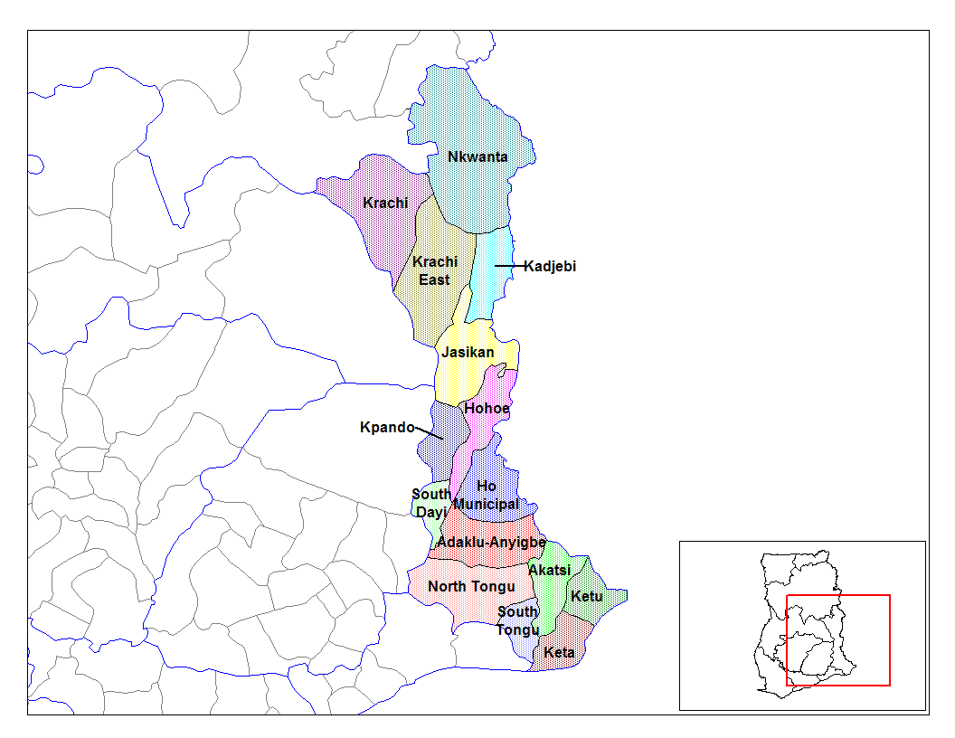
English: Map of the districts of the Volta region of Ghana. Created by Rarelibra for public domain use. Created using MapInfo Professional v7.5 and various mapping resources. |
| Date | 28 juin 2006 (date de téléversement originale) |
| Source | Travail personnel |
| Auteur | User:Rarelibra |
Conditions d’utilisation
| Public domainPublic domainfalsefalse |
| Moi, propriétaire des droits d’auteur sur cette œuvre, la place dans le domaine public. Ceci s'applique dans le monde entier. Dans certains pays, ceci peut ne pas être possible ; dans ce cas : J’accorde à toute personne le droit d’utiliser cette œuvre dans n’importe quel but, sans aucune condition, sauf celles requises par la loi. |
Journal des téléversements d’origine
- (del) (cur) 08:03, 5 March 2006 . . Rarelibra (Talk | contribs) . . 1056x816 (44,138 bytes) (Map of the districts of the Volta region of Ghana. Created by Rarelibra for public domain use. Created using MapInfo Professional v7.5 and various mapping resources.)
Légendes
Ajoutez en une ligne la description de ce que représente ce fichier
Éléments décrits dans ce fichier
dépeint
28 juin 2006
Historique du fichier
Cliquer sur une date et heure pour voir le fichier tel qu'il était à ce moment-là.
| Date et heure | Vignette | Dimensions | Utilisateur | Commentaire | |
|---|---|---|---|---|---|
| actuel | 28 juin 2006 à 16:01 | | 1 056 × 816 (43 kio) | Ahanta | from en:districts of ghana Map of the districts of the Volta region of Ghana. Created by Rarelibra for public domain use. Created using MapInfo Professional v7.5 and various mapping resources. [edit] I, the creator of this work, hereby release it into th |
Utilisation du fichier
Les 22 pages suivantes utilisent ce fichier :
- Adaklu-Anyigbe
- Akatsi
- Biakoye
- Dayi sud
- District (Ghana)
- District municipal d'Ho
- District municipal d'Hohoe
- District municipal de Keta
- Jasikan
- Kadjebi
- Ketu nord
- Ketu sud
- Kpando
- Krachi est
- Krachi ouest
- Nkwanta nord
- Nkwanta sud
- Région de la Volta
- Tongu nord
- Tongu sud
- Modèle:Infobox District du Ghana
- Modèle:Infobox District du Ghana/Documentation
Usage global du fichier
Les autres wikis suivants utilisent ce fichier :
- Utilisation sur ca.wikipedia.org
- Utilisation sur ceb.wikipedia.org
- Utilisation sur dag.wikipedia.org
- Utilisation sur da.wikipedia.org
- Utilisation sur de.wikipedia.org
- Utilisation sur ee.wikipedia.org
- Utilisation sur en.wikipedia.org
- Utilisation sur es.wikipedia.org
- Utilisation sur fa.wikipedia.org
- Utilisation sur gpe.wikipedia.org
- Utilisation sur ha.wikipedia.org
- Utilisation sur ig.wikipedia.org
- Utilisation sur it.wikipedia.org
- Utilisation sur ja.wikipedia.org
- Utilisation sur ko.wikipedia.org
- Utilisation sur la.wikipedia.org
- Utilisation sur nl.wikipedia.org
- Utilisation sur no.wikipedia.org
- Utilisation sur pl.wikipedia.org
- Utilisation sur pt.wikipedia.org
- Utilisation sur ro.wikipedia.org
Voir davantage sur l’utilisation globale de ce fichier.
Ce document provient de « https://fr.wikipedia.org/wiki/Fichier:Volta_districts.png ».