File:EB_1911_Map_Fig_6.png
De Wikipedia, l'encyclopédie encyclopedia
Taille de cet aperçu : 800 × 543 pixels. Autres résolutions : 320 × 217 pixels | 640 × 435 pixels | 1 024 × 695 pixels | 1 280 × 869 pixels | 2 350 × 1 596 pixels.
Fichier d’origine (2 350 × 1 596 pixels, taille du fichier : 2,25 Mio, type MIME : image/png)
Ce fichier et sa description proviennent de Wikimedia Commons.
Description
| DescriptionEB 1911 Map Fig 6.png |
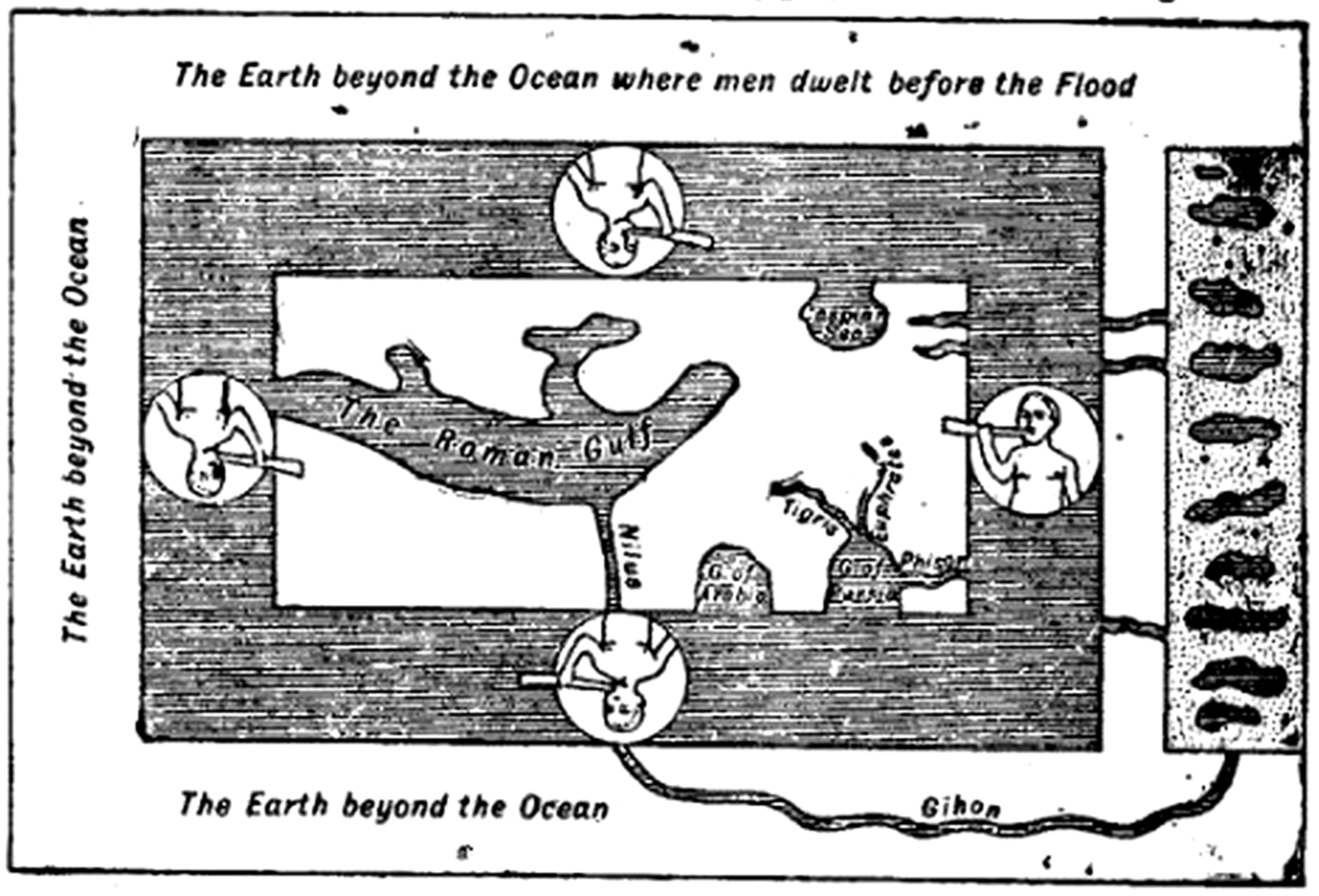
English: Caption: "Fig. 6.—The World according to Cosmas Indicopleustes (535)." Cosmas gave the surface of the Earth as a flat rectangle holding up the vault of the sky, the whole making the shape of the Israelite Tabernacle [not shown]. The World Ocean does not encircle all land, but only the currently inhabited world (i.e., Afroeurasia). The outer shore comprises "The Earth beyond the Ocean where men dwelt before the Flood" (N), "The Earth beyond the Ocean" (W & S), and the [here unlabeled] Garden of Eden from which flow four rivers including the "Gihon"/"Nilus" and "Phisor". The rivers were considered to run through the World Ocean as a current and then to have reëntered the land in Transoxiana, Persia, and Ethiopia. |
| Date |
vers 1911 date QS:P,+1911-00-00T00:00:00Z/9,P1480,Q5727902 (archetype written sometime after ad 535) |
| Source | "Map" in the Encyclopaedia Britannica, 11th ed., Vol. XVII, p. 637. After Cosmas's Christian Topography. |
| Auteur | AnonymeUnknown author (presumably Emery Walker), reconstructing the map of Cosmas Indicopleustes. |
| Autorisation (Réutilisation de ce fichier) |
PD-US; PD-Britannica |
| Autres versions |
|


Conditions d’utilisation
| Public domainPublic domainfalsefalse |
Ce document est dans le domaine public aux États-Unis. Ceci s'applique aux travaux des États-Unis où le copyright a expiré, souvent parce que sa première publication s'est produite avant le 1er janvier 1929. Voir cette page pour davantage d'explication.
|
 | |
 |
Cette image peut ne pas être dans le domaine public en dehors des États-Unis (ceci s'applique particulièrement au Canada, en Chine (pas Hong Kong, Macao, ni Taïwan), en Allemagne ou en Suisse). Le créateur et l'année de la publication sont l'information essentielle et doivent être fournis.
|
| Public domainPublic domainfalsefalse |
| This image comes from the 13th edition of the Encyclopædia Britannica or earlier. The copyrights for that book have expired in the United States because the book was first published in the US with the publication occurring before January 1, 1929. As such, this image is in the public domain in the United States. |  |
| Annotations InfoField | Cette image est annotée : Voir les annotations sur Wikimedia Commons |
1481
973
109
129
2350
1596
G. of Persia (Persian Gulf)
1246
979
118
115
2350
1596
G. of Arabia (Red Sea)
1530
761
91
212
2350
1596
Euphrates
1090
917
76
162
2350
1596
Nilus (Nile R.)
1360
858
144
112
2350
1596
Tigris
1416
529
165
94
2350
1596
Caspian Sea
582
732
596
88
2350
1596
The Roman Gulf (Mediterranean Sea)
1619
1402
185
59
2350
1596
Gihon
297
85
1748
118
2350
1596
The Earth beyond the Ocean where men dwelt before the Flood
1583
967
144
56
2350
1596
Phisor
Légendes
Ajoutez en une ligne la description de ce que représente ce fichier
Éléments décrits dans ce fichier
dépeint
image/png
Historique du fichier
Cliquer sur une date et heure pour voir le fichier tel qu'il était à ce moment-là.
| Date et heure | Vignette | Dimensions | Utilisateur | Commentaire | |
|---|---|---|---|---|---|
| actuel | 31 mars 2015 à 01:23 | | 2 350 × 1 596 (2,25 Mio) | LlywelynII | User created page with UploadWizard |
Utilisation du fichier
Aucune page n’utilise ce fichier.
Usage global du fichier
Les autres wikis suivants utilisent ce fichier :
- Utilisation sur en.wikisource.org
Ce document provient de « https://fr.wikipedia.org/wiki/Fichier:EB_1911_Map_Fig_6.png ».