File:ElectoralCollege2000-Large.png
De Wikipedia, l'encyclopédie encyclopedia
Taille de cet aperçu : 800 × 430 pixels. Autres résolutions : 320 × 172 pixels | 640 × 344 pixels | 1 182 × 635 pixels.
Fichier d’origine (1 182 × 635 pixels, taille du fichier : 175 kio, type MIME : image/png)
Ce fichier et sa description proviennent de Wikimedia Commons.
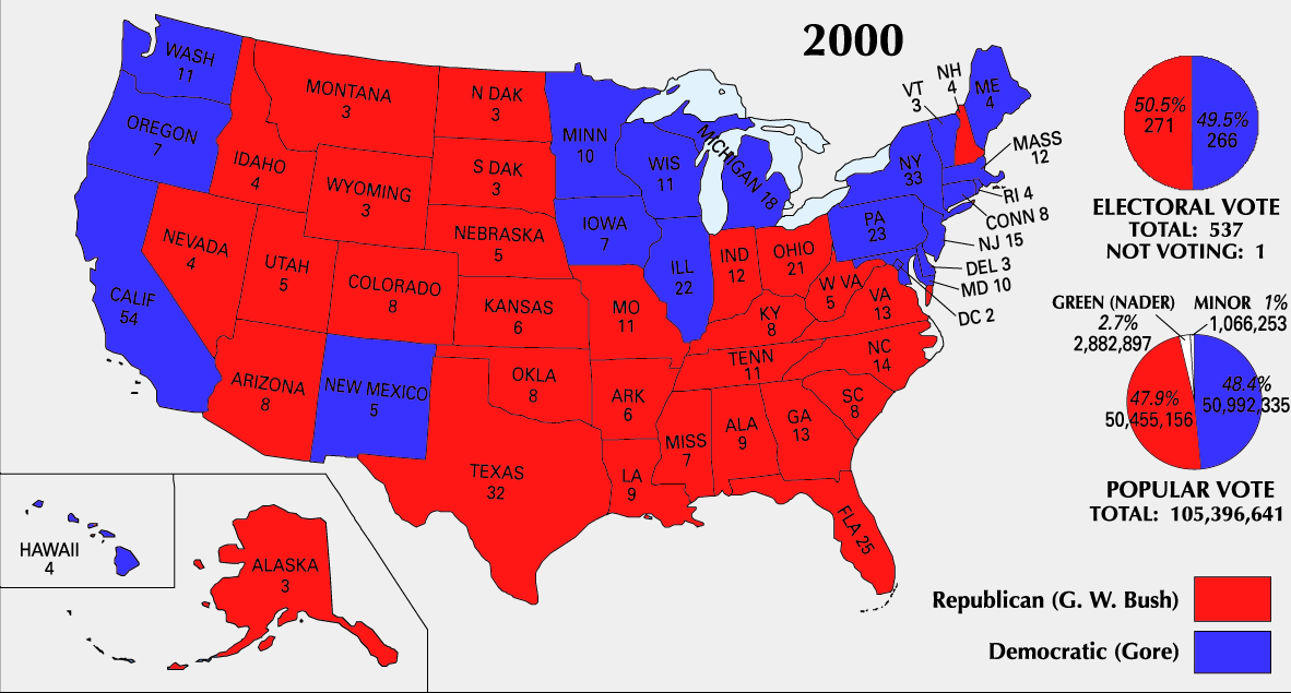
| U.S. presidential election maps from the National Atlas of the United States |
| See also: SVG maps |
| 1789 · 1792 · 1796 · 1800 · 1804 · 1808 · 1812 · 1816 · 1820 · 1824 · 1828 · 1832 · 1836 · 1840 · 1844 · 1848 · 1852 · 1856 · 1860 · 1864 · 1868 · 1872 · 1876 · 1880 · 1884 · 1888 · 1892 · 1896 · 1900 · 1904 · 1908 · 1912 · 1916 · 1920 · 1924 · 1928 · 1932 · 1936 · 1940 · 1944 · 1948 · 1952 · 1956 · 1960 · 1964 · 1968 · 1972 · 1976 · 1980 · 1984 · 1988 · 1992 · 1996 · 2000 · 2004 |
Description


Conditions d’utilisation
| Public domainPublic domainfalsefalse |
Cette carte a été obtenue d'une édition du
National Atlas of the United States . Comme presque toutes les œuvres du gouvernement fédéral des États-Unis d'Amérique, les travaux du National Atlas sont placés dans le domaine public.Version en ligne : NationalAtlas.gov | Édition imprimée de 1970 : Library of Congress, Perry-Castañeda Library čeština | Deutsch | English | français | Bahasa Indonesia | italiano | македонски | മലയാളം | sicilianu | 中文 | 中文(简体) | 中文(繁體) | +/− |
Historique du fichier
Cliquer sur une date et heure pour voir le fichier tel qu'il était à ce moment-là.
| Date et heure | Vignette | Dimensions | Utilisateur | Commentaire | |
|---|---|---|---|---|---|
| actuel | 26 juin 2008 à 01:51 | | 1 182 × 635 (175 kio) | Tallicfan20 | better resolution |
| 14 février 2008 à 03:02 |  | 1 182 × 635 (83 kio) | SteveSims~commonswiki | Reverted to version as of 10:23, 25 July 2007. The version with Nader as green didn't look very good. | |
| 8 février 2008 à 00:08 |  | 1 182 × 635 (2,15 Mio) | SteveSims~commonswiki | Ralph Nader's popular votes made green. Also public domain. | |
| 25 juillet 2007 à 12:23 |  | 1 182 × 635 (83 kio) | Cardsplayer4life~commonswiki | Reverted to earlier revision | |
| 25 juillet 2007 à 11:46 |  | 1 182 × 635 (62 kio) | Joseph Solis in Australia~commonswiki | {{PD-USGov-Atlas}} Category:2000 {{US presidential election maps}} | |
| 2 juillet 2007 à 04:30 |  | 1 182 × 635 (83 kio) | Cardsplayer4life~commonswiki | {{PD-USGov-Atlas}} Source: EN Wiki {{US presidential election maps}} | |
| 29 juin 2007 à 12:08 |  | 1 182 × 635 (62 kio) | Joseph Solis in Australia~commonswiki | {{PD-USGov-Atlas}} Category:2000 {{US presidential election maps}} | |
| 21 juin 2007 à 23:04 |  | 1 182 × 635 (83 kio) | Cardsplayer4life~commonswiki | {{PD-USGov-Atlas}} Category:2000 {{US presidential election maps}} | |
| 19 août 2005 à 12:21 |  | 1 182 × 635 (62 kio) | Ondrejk | {{PD-USGov-Atlas}} Source: EN Wiki |
Utilisation du fichier
Aucune page n’utilise ce fichier.
Usage global du fichier
Les autres wikis suivants utilisent ce fichier :
- Utilisation sur el.wikipedia.org
- Utilisation sur en.wikipedia.org
- Utilisation sur fa.wikipedia.org
- Utilisation sur sv.wikipedia.org
- Utilisation sur uk.wikipedia.org
Ce document provient de « https://fr.wikipedia.org/wiki/Fichier:ElectoralCollege2000-Large.png ».