Íomhá:Map_of_USA_AK_full.png
From Wikipedia, the free encyclopedia
Níl aon taifeach is mó ar fáil.
Map_of_USA_AK_full.png (284 × 184 picteilín, méid comhaid: 19 KB, cineál MIME: image/png)
| Seo comhad as An Cómhaoin Viciméid. Tá an tuairisc as an leathanach tuairisc Cómhaoin a leanas thíos.
|

|
File:Map of USA AK full.svg is a vector version of this file. It should be used in place of this PNG file when not inferior.
File:Map of USA AK full.png → File:Map of USA AK full.svg
For more information, see Help:SVG.
|
 |
Achoimriú
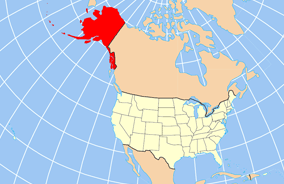
| TuairiscMap of USA AK full.png | Map of USA with Alaska highlighted and shown in true position |
| Dáta | |
| Foinse | http://www.nationalatlas.gov/printable/reference.html |
| Údar |
Níl aon eolas faoin údar an meáin seo.
|
| Leaganacha eile | File:Map of USA AK full.svg |
Ceadúnú
| Public domainPublic domainfalsefalse |
This map was obtained from an edition of the National Atlas of the United States. Like almost all works of the U.S. federal government, works from the National Atlas are in the public domain in the United States.
Online access: NationalAtlas.gov | 1970 print edition: Library of Congress, Perry-Castañeda Library čeština | Deutsch | English | français | Bahasa Indonesia | italiano | македонски | മലയാളം | sicilianu | 中文 | 中文(简体) | 中文(繁體) | +/− |
Captions
Add a one-line explanation of what this file represents
Аляска и остальные штаты США на карте Северной Америки
Items portrayed in this file
taispeánann sé/sí
2 Aibreán 2007
Stair chomhaid
Cliceáil ar dáta/am chun an comhad a radharc mar a bhí sé ag an am sin.
| Dáta/Am | Mionsamhail | Toisí | Úsáideoir | Nóta tráchta | |
|---|---|---|---|---|---|
| faoi láthair | 20:43, 17 Nollaig 2012 | | 284 × 184 (19 KB) | Ras67 | cropped |
| 16:31, 2 Aibreán 2007 |  | 286 × 186 (20 KB) | MattWright | fix to more standard map colors | |
| 06:20, 2 Aibreán 2007 |  | 286 × 186 (19 KB) | MattWright | {{Information |Description=Map of USA with Alaska highlighted and shown in true position |Source=http://www.nationalatlas.gov/printable/reference.html |Date=2007-04-02 |Author= |Permission= |other_versions= }} Category:Maps of the United States [[Cat |
Úsáid comhaid
Tá nasc chuig an gcomhad seo ar 21 an leathanach seo a leanas:
- Buirg Aleutians Thoir, Alasca
- Buirg Anchorage, Alasca
- Buirg Artach Thiar Thuaidh, Alasca
- Buirg Bristol Bay, Alasca
- Buirg Denali, Alasca
- Buirg Fairbanks Réalta Thuaidh, Alasca
- Buirg Fána Taobh Thuaidh, Alasca
- Buirg Haines, Alasca
- Buirg Juneau, Alasca
- Buirg Leithinis Kenai, Alasca
- Buirg Loch agus Leithinis, Alasca
- Buirg Matanuska-Susitna, Alasca
- Buirg Neamheagraithe, Alasca
- Buirg Oileán Kodiak, Alasca
- Buirg Petersburg, Alasca
- Buirg Sitka, Alasca
- Buirg Skagway, Alasca
- Buirg Tairseach Ketchikan, Alasca
- Buirg Wrangell, Alasca
- Buirg Yakutat, Alasca
- Sitka
Global file usage
The following other wikis use this file:
- Úsáid ar am.wikipedia.org
- Úsáid ar ar.wikipedia.org
- Úsáid ar az.wikipedia.org
- Úsáid ar az.wiktionary.org
- Úsáid ar ba.wikipedia.org
- Úsáid ar bn.wikipedia.org
- Úsáid ar ce.wikipedia.org
- Úsáid ar cy.wikipedia.org
- Úsáid ar da.wikipedia.org
- Úsáid ar de.wikipedia.org
- Úsáid ar el.wikipedia.org
- Úsáid ar en.wikipedia.org
- Úsáid ar es.wikibooks.org
- Úsáid ar fa.wikipedia.org
- Úsáid ar fr.wikinews.org
- Úsáid ar he.wikipedia.org
- Úsáid ar hu.wikipedia.org
View more global usage of this file.