Faidhle:ScotlandTradNumbered.png
From Wikipedia, the free encyclopedia
Chan eil dùmhlachd-bhreacaidh nas fhearr ri fhaighinn.
ScotlandTradNumbered.png (400 × 504 pixel, meud an fhaidhle: 104 KB, seòrsa MIME: image/png)
'S ann à Wikimedia Commons a tha am faidhle seo agus faodaidh gu bheil pròiseactan eile 'ga chleachdadh. Chì thu an tuairisgeul a tha aice air [duilleag tuairisgeul an fhaidhle https://commons.wikimedia.org/wiki/File:ScotlandTradNumbered.png] gu h-ìosal.

|
This locator map image could be re-created using vector graphics as an SVG file. This has several advantages; see Commons:Media for cleanup for more information. If an SVG form of this image is available, please upload it and afterwards replace this template with
{{vector version available|new image name}}.
It is recommended to name the SVG file “ScotlandTradNumbered.svg”—then the template Vector version available (or Vva) does not need the new image name parameter. |
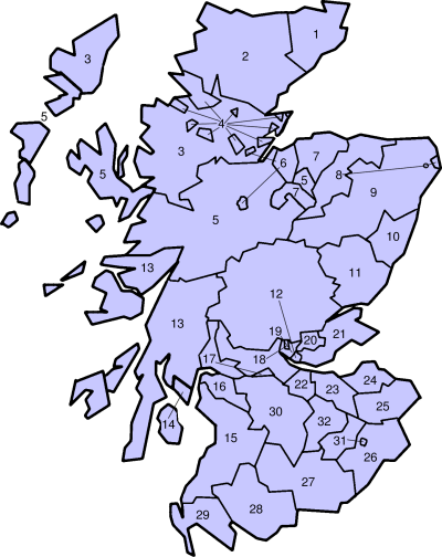
Traditional counties of Scotland
Slightly edited version of a map originally drawn by Morwen
- Caithness
- Sutherland
- Ross-shire
- Cromartyshire
- Inverness-shire
- Nairnshire
- Morayshire
- Banffshire
- Aberdeenshire
- Kincardineshire
- Angus
- Perthshire
- Argyll
- Bute
- Ayrshire
- Renfrewshire
- Dunbartonshire
- Stirlingshire
- Clackmannanshire
- Kinross-shire
- Fife
- West Lothian
- Mid Lothian
- East Lothian
- Berwickshire
- Roxburghshire
- Dumfriesshire
- Kirkcudbrightshire
- Wigtownshire
- Lanarkshire
- Selkirkshire
- Peeblesshire

|
Permission is granted to copy, distribute and/or modify this document under the terms of the GNU Free Documentation License, Version 1.2 or any later version published by the Free Software Foundation; with no Invariant Sections, no Front-Cover Texts, and no Back-Cover Texts. A copy of the license is included in the section entitled GNU Free Documentation License.http://www.gnu.org/copyleft/fdl.htmlGFDLGNU Free Documentation Licensetruetrue |
| Tha am faidhle seo fo cheadachas Creative Commons Attribution-Share Alike 3.0 Unported. | ||
| ||
| This licensing tag was added to this file as part of the GFDL licensing update.http://creativecommons.org/licenses/by-sa/3.0/CC BY-SA 3.0Creative Commons Attribution-Share Alike 3.0truetrue |
Captions
Add a one-line explanation of what this file represents
Items portrayed in this file
depicts Beurla
copyright status Beurla
copyrighted Beurla
Eachdraidh an fhaidhle
Briog air ceann-là/àm gus am faidhle a shealltainn mar a nochd e aig an àm sin.
| Ceann-là/Àm | Dealbhag | Meud | Cleachdaiche | Beachd | |
|---|---|---|---|---|---|
| làithreach | 19:29, 29 dhen Chèitean 2005 | | 400 × 504 (104 KB) | Bastique | Replaces image in other wikis. From en.wiki {{GFDL}} |
| 19:05, 18 dhen Chèitean 2005 |  | 420 × 520 (13 KB) | Voyager | Traditional counties of Scotland Slightly edited version of a map originally drawn by Morwen {{GFDL}} Category:Maps of Scottish traditional counties |
Cleachdadh an fhaidhle
Tha ceangal ris an fhaidhle seo san duilleag a leanas:
Cleachdadh fhaidhlichean uile-choitcheann
Tha na uicidhean eile a leanas a’ cleachdadh an fhaidhle seo
- Cleachdadh air bar.wikipedia.org
- Cleachdadh air br.wikipedia.org
- Cleachdadh air cs.wikipedia.org
- Cleachdadh air de.wikipedia.org
- Cleachdadh air en.wikipedia.org
- Cleachdadh air es.wikipedia.org
- Cleachdadh air fr.wikipedia.org
- Cleachdadh air fy.wikipedia.org
- Cleachdadh air ga.wikipedia.org
- Cleachdadh air hy.wikipedia.org
- Cleachdadh air it.wikipedia.org
- Cleachdadh air ja.wikipedia.org
- Cleachdadh air nl.wikipedia.org
- Cleachdadh air nn.wikipedia.org
- Cleachdadh air no.wikipedia.org
- Cleachdadh air pt.wikipedia.org
- Cleachdadh air sco.wikipedia.org
- Cleachdadh air sh.wikipedia.org
- Cleachdadh air sv.wikipedia.org
- Cleachdadh air tr.wikipedia.org
- Cleachdadh air zh.wikipedia.org
Air a tharraing à "https://gd.wikipedia.org/wiki/Faidhle:ScotlandTradNumbered.png"