File:France_Pays_bretons_map.jpg
From Wikipedia, the free encyclopedia
Jeeskeaylley ymlane (1,500 × 1,189 pixelyn, mooadys y choadan: 815 KB, sorçh MIME: image/jpeg)
This file is from Wikimedia Commons and may be used by other projects. The description on its file description page there is shown below.

|
File:France Pays bretons map.svg is a vector version of this file. It should be used in place of this JPG file when not inferior.
File:France Pays bretons map.jpg → File:France Pays bretons map.svg
For more information, see Help:SVG.
|
 |
Giare-choontey
| CoonteyFrance Pays bretons map.jpg |
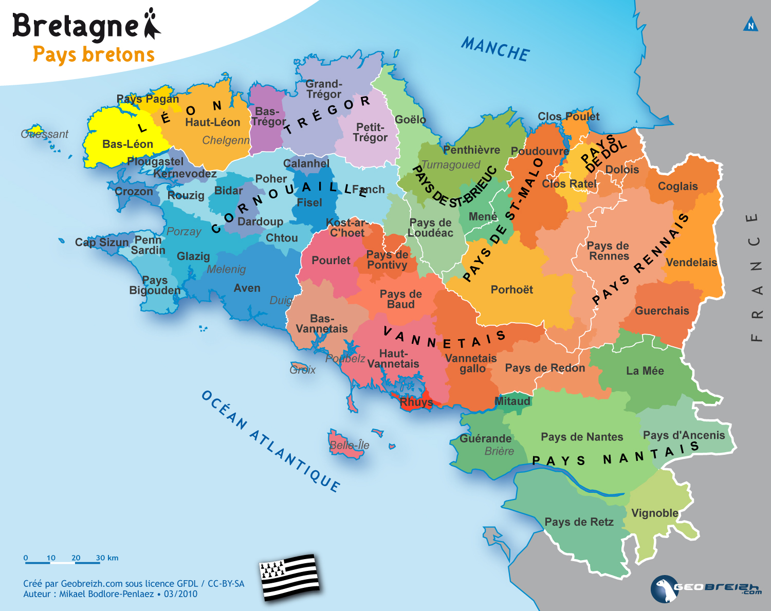
Brezhoneg: Kartenn broioù hengounel Breizh.
English: Map of the traditionnal regions of Brittany (France)
Français : Carte des pays traditionnels bretons. |
||
| Date | |||
| Bun | http://www.geobreizh.com/breizh/fra/carte-pays-trad.asp | ||
| Author | Mikael Bodlore-Penlaez | ||
| Permission (Reusing this file) |
|
||
| Other versions |
[reagh]
|


Kieddagh:

|
Permission is granted to copy, distribute and/or modify this document under the terms of the GNU Free Documentation License, Version 1.2 or any later version published by the Free Software Foundation; with no Invariant Sections, no Front-Cover Texts, and no Back-Cover Texts. A copy of the license is included in the section entitled GNU Free Documentation License.http://www.gnu.org/copyleft/fdl.htmlGFDLGNU Free Documentation Licensetruetrue |
- You are free:
- to share – to copy, distribute and transmit the work
- to remix – to adapt the work
- Under the following conditions:
- attribution – You must give appropriate credit, provide a link to the license, and indicate if changes were made. You may do so in any reasonable manner, but not in any way that suggests the licensor endorses you or your use.
- share alike – If you remix, transform, or build upon the material, you must distribute your contributions under the same or compatible license as the original.
Captions
Items portrayed in this file
depicts English
copyright status English
copyrighted English
copyright license English
30 Mayrnt 2010
Shennaghys y choadan
Crig er daayt/am ennagh son fakin er y choadan myr v’eh ec y traa shen.
| Daayt/Am | Ingin-ordaag | Towshanyn | Ymmydeyr | Cohaggloo | |
|---|---|---|---|---|---|
| bio | 12:59, 31 Mayrnt 2010 | | 1,500 × 1,189 (815 KB) | Pethrus | {{Information |Description={{en|Map of the traditionnal regions of Bretagne (France)}}{{fr|Carte des pays traditionnels bretons}} |Source=[http://www.geobreizh.com www.geobreizh.com], Mikael Bodlore-Pentaez |Date=2010-03-30 |Author=Mikael Bodlore-Pentaez |
Ymmyd y choadan
Cha nel duillag erbee kianglt rish y choadan shoh.
Global file usage
The following other wikis use this file:
- Usage on cy.wikipedia.org
- Usage on de.wikipedia.org
- Usage on fr.wikipedia.org
- Usage on hu.wikipedia.org
Metadata
Ta'n coadan shoh goaill tooilley fysseree stiagh, currit veih'n çhamraig vun-earrooagh ny yn scanreyder, as eh ymmydit dys y coadan y chroo ny y yannoo bun-earrooagh, s'liklee.
My vel y coadan ceaghlit veih'n chummey bunneydagh, foddee nagh beagh mynphoyntyn ennagh cohoilshaghey yn coadan ceaghlit.
| _error | 0 |
|---|