File:Wawa_footprint_2012-07.png
From Wikipedia, the free encyclopedia
Az előnézet mérete: 548 × 599 képpont További felbontások: 220 × 240 képpont | 439 × 480 képpont | 644 × 704 képpont.
Eredeti fájl (644 × 704 képpont, fájlméret: 138 KB, MIME-típus: image/png)
|
Ez a fájl a Wikimedia Commonsból származik. Az alább látható leírás az ottani dokumentációjának másolata. A Commons projekt szabad licencű kép- és multimédiatár. Segíts te is az építésében! |
Összefoglaló


| Point Maps
══▻ FAQ ◅══ ══▻ Create your own ◅══ |
Licenc
Ez a fájl a Creative Commons Nevezd meg! – Így add tovább! 3.0 Unported licenc alapján használható fel.
- A következőket teheted a művel:
- megoszthatod – szabadon másolhatod, terjesztheted, bemutathatod és előadhatod a művet
- feldolgozhatod – származékos műveket hozhatsz létre
- Az alábbi feltételekkel:
- Nevezd meg! – A szerzőt megfelelően fel kell tüntetned, hivatkozást kell létrehoznod a licencre és jelezned kell, ha a művön változtatást hajtottál végre. Ezt bármilyen észszerű módon megteheted, kivéve oly módon, ami azt sugallná hogy a jogosult támogat téged vagy a felhasználásod körülményeit.
- Így add tovább! – Ha megváltoztatod, átalakítod, feldolgozod ezt a művet, a közreműködésedet csak az eredetivel megegyező vagy hasonló licenc alatt terjesztheted.
Eredeti feltöltési napló
This image is a derivative work of the following images:
- File:USA_Pennsylvania_location_map.svg licensed with Cc-by-3.0, GFDL
- 2009-07-05T11:11:22Z Alexrk2 1201x805 (429769 Bytes) == Beschreibung == {{Information |Description= {{de|Positionskarte von [[:de:Pennsylvania|Pennsylvania]], [[:de:USA|USA]]}} Quadratische Plattkarte, N-S-Streckung 130.0 %. Geographische Begrenzung der Karte: * N: 42.7° N * S
- File:USA_New_Jersey_location_map.svg licensed with Cc-by-3.0, GFDL
- 2009-06-17T19:59:27Z Alexrk2 839x1560 (259806 Bytes) enh
- 2009-06-13T18:01:16Z Alexrk 839x1560 (198653 Bytes) fixed SVG bug
- 2009-06-13T17:46:17Z Alexrk 839x1560 (246056 Bytes) == Beschreibung == {{Information |Description= {{de|Positionskarte von [[:de:New Jersey|New Jersey]], [[:de:USA|USA]]}} Quadratische Plattkarte, N-S-Streckung 130.0 %. Geographische Begrenzung der Karte: * N: 41.6° N * S: 38
- File:USA_Maryland_location_map.svg licensed with Cc-by-3.0, GFDL
- 2009-06-22T11:30:38Z Alexrk2 1200x764 (463352 Bytes) fixed border
- 2009-06-22T11:23:05Z Alexrk2 1200x764 (459278 Bytes) crop height
- 2009-06-22T11:03:54Z Alexrk2 1201x955 (455501 Bytes) renderer bug
- 2009-06-22T10:42:06Z Alexrk2 800x636 (318450 Bytes) == Beschreibung == {{Information |Description= {{de|Positionskarte von [[:de:Maryland|Maryland]], [[:de:USA|USA]]}} Quadratische Plattkarte, N-S-Streckung 130.0 %. Geographische Begrenzung der Karte: * N: 40.3° N * S: 37.3°
- File:USA_New_York_location_map.svg licensed with Cc-by-3.0, GFDL
- 2009-06-10T11:28:20Z NordNordWest 1572x1277 (597043 Bytes) {{Information |Description= {{de|Positionskarte vom Bundesstaat [[:de:New York (Bundesstaat)|New York]], [[:de:USA|USA]]}} Quadratische Plattkarte, N-S-Streckung 135 %. Geographische Begrenzung der Karte: * N: 45.3° N * S: 4
- File:USA_Virginia_location_map.svg licensed with Cc-by-3.0, GFDL
- 2009-07-06T18:02:25Z Alexrk2 1500x964 (963271 Bytes) resize
- 2009-06-26T16:42:40Z Alexrk2 1201x772 (966691 Bytes) == Beschreibung == {{Information |Description= {{de|Positionskarte von [[:de:Virginia|Virginia]], [[:de:USA|USA]]}} Quadratische Plattkarte, N-S-Streckung 130.0 %. Geographische Begrenzung der Karte: * N: 40.2° N * S: 35.8°
- File:USA_West_Virginia_location_map.svg licensed with Cc-by-3.0, GFDL
- 2009-07-03T15:31:49Z Alexrk2 1201x1118 (535137 Bytes) == Beschreibung == {{Information |Description= {{de|Positionskarte von [[:de:West Virginia|West Virginia]], [[:de:USA|USA]]}} Quadratische Plattkarte, N-S-Streckung 130.0 %. Geographische Begrenzung der Karte: * N: 40.8° N *
- File:USA_Florida_location_map.svg licensed with Cc-by-3.0
- 2008-12-15T20:25:08Z Sting 1132x1096 (591820 Bytes) Counties boundaries: thinner strokes
- 2008-12-15T19:49:40Z Sting 1132x1096 (591829 Bytes) == Summary == {{Location|27|45|00|N|83|49|30|W|scale:4000000}} {{Information |Description={{en|Blank administrative map of the State of [[:en:Florida|Florida]], [[:en:United States|USA]], for geo-location purpose, with count
- File:USA_Connecticut_location_map.svg licensed with Cc-by-3.0, GFDL
- 2009-06-25T19:16:48Z Alexrk2 800x678 (154250 Bytes) renderer bug
- 2009-06-25T19:14:39Z Alexrk2 800x678 (155149 Bytes) == Beschreibung == {{Information |Description= {{de|Positionskarte von [[:de:Connecticut|Connecticut]], [[:de:USA|USA]]}} Quadratische Plattkarte, N-S-Streckung 130.0 %. Geographische Begrenzung der Karte: * N: 42.3° N * S:
- File:USA_North_Carolina_location_map.svg licensed with Cc-by-3.0, GFDL
- 2010-04-25T12:44:25Z Alexrk2 1400x849 (1201046 Bytes) enh rivers, aligned state borders
- 2009-06-26T22:06:53Z Alexrk2 1400x849 (894030 Bytes) resize
- 2009-06-26T21:57:18Z Alexrk2 1400x849 (896940 Bytes) resize
- 2009-06-26T21:47:07Z Alexrk2 1201x728 (930560 Bytes) == Beschreibung == {{Information |Description= {{de|Positionskarte von [[:de:North Carolina|North Carolina]], [[:de:USA|USA]]}} Quadratische Plattkarte, N-S-Streckung 120.0 %. Geographische Begrenzung der Karte: * N: 37.5° N
- File:USA_Delaware_location_map.svg licensed with Cc-by-3.0, GFDL
- 2009-06-22T10:54:18Z Alexrk2 470x800 (106507 Bytes) renderer bug
- 2009-06-22T10:39:54Z Alexrk2 470x800 (66078 Bytes) == Beschreibung == {{Information |Description= {{de|Positionskarte von [[:de:Delaware|Delaware]], [[:de:USA|USA]]}} Quadratische Plattkarte, N-S-Streckung 130.0 %. Geographische Begrenzung der Karte: * N: 40.0° N * S: 38.3°
Uploaded with derivativeFX
Képaláírások
Adj meg egy egysoros magyarázatot arról, hogy mit mutat be ez a fájl
A fájl által ábrázolt elemek
mű tárgya
31. július 2012
Fájltörténet
Kattints egy időpontra, hogy a fájl akkori állapotát láthasd.
| Dátum/idő | Bélyegkép | Felbontás | Feltöltő | Megjegyzés | |
|---|---|---|---|---|---|
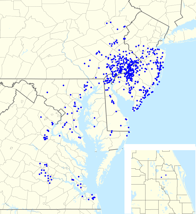
| aktuális | 2012. augusztus 1., 00:57 | | 644 × 704 (138 KB) | Magog the Ogre | == {{int:filedesc}} == {{Information |Description={{en|1=Footprint of en:Wawa Inc. as of {{ISOdate|2011-06-25}}.}} |Source={{Derived from|USA_Pennsylvania_location_map.svg|USA_New_Jersey_location_map.svg|USA_Maryland_location_map.svg|USA_New_York... |
Fájlhasználat
Ezt a fájlt nem használja egyetlen lap sem.
Metaadatok
Ez a kép járulékos adatokat tartalmaz, amelyek feltehetően a kép létrehozásához használt digitális fényképezőgép vagy lapolvasó beállításairól adnak tájékoztatást. Ha a képet az eredetihez képest módosították, ezen adatok eltérhetnek a kép tényleges jellemzőitől.
| Vízszintes felbontás | 35,43 dpc |
|---|---|
| Függőleges felbontás | 35,43 dpc |
| Utolsó változtatás ideje | 2012. július 31., 22:42 |
A lap eredeti címe: „https://hu.wikipedia.org/wiki/Fájl:Wawa_footprint_2012-07.png”