Պատկեր:1864_Johnson_Map_of_the_Roman_Empire_-_Geographicus_-_RomanEmpire-johnson-1864.jpg
From Wikipedia, the free encyclopedia
Նախադիտման չափ՝ 800 × 493 պիքսել։ Այլ թույլտվությաններ: 320 × 197 պիքսել | 640 × 395 պիքսել | 1024 × 632 պիքսել | 1280 × 789 պիքսել | 2560 × 1579 պիքսել | 4000 × 2467 պիքսել.
Սկզբնական նիշք (4000 × 2467 փիքսել, նիշքի չափը՝ 3,46 ՄԲ, MIME-տեսակը՝ image/jpeg)
Այս նիշքը տեղադրված է Վիքիպահեստում է և այն կարող է օգտագործվել այլ նախագծերի կողմից։ Վիքիպահեստում նիշքի մասին տեղեկությունների հիմնական մասը ներկայացված է ստորև։
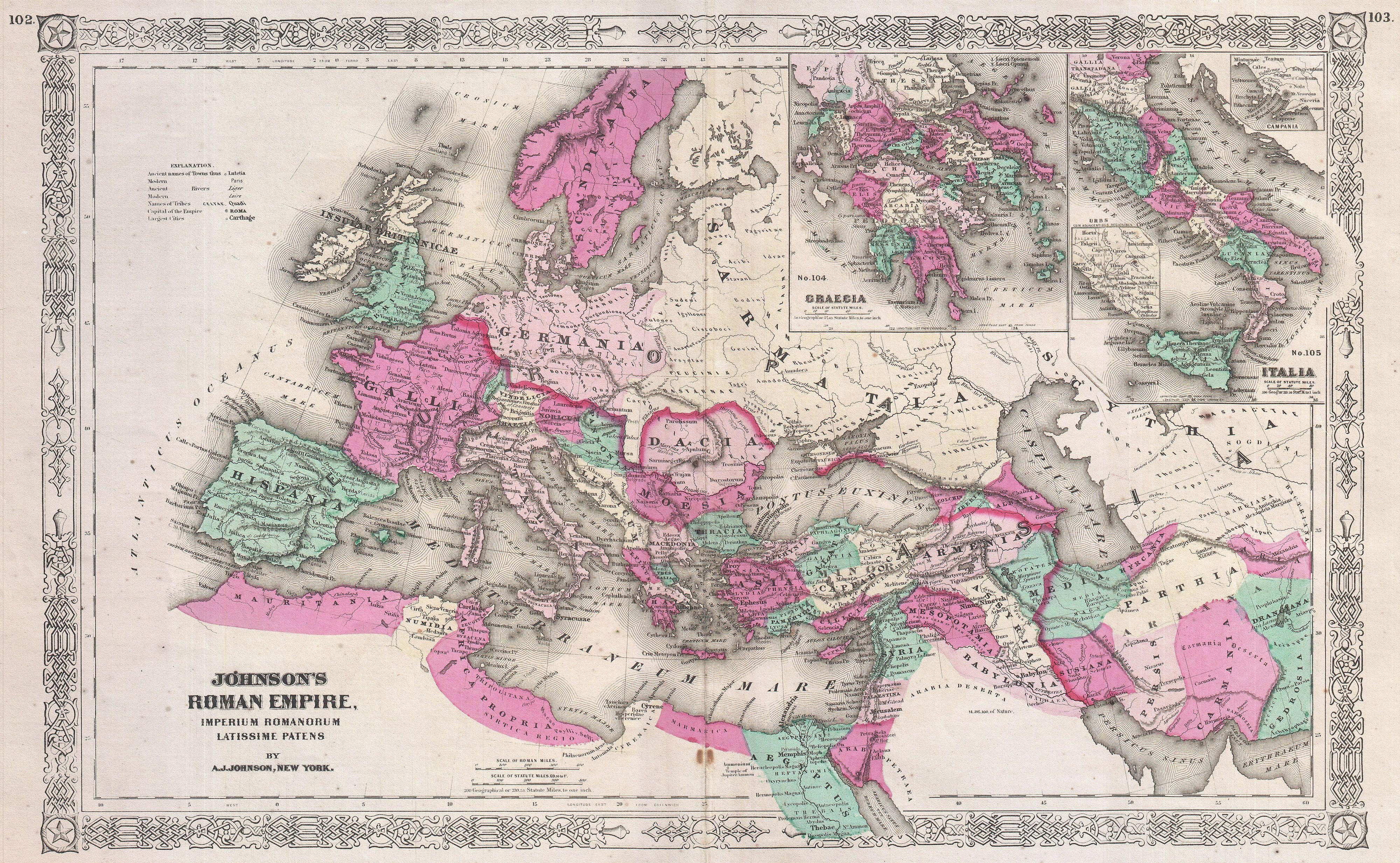
| Alvin Jewett Johnson: Johnson's Roman Empire, Imperium Romanorum Latissime Patens.
( |
|||||||||||||||||||||||
|---|---|---|---|---|---|---|---|---|---|---|---|---|---|---|---|---|---|---|---|---|---|---|---|
| Նկարիչ |
artist QS:P170,Q18507750 |
||||||||||||||||||||||
| Title |
Johnson's Roman Empire, Imperium Romanorum Latissime Patens. |
||||||||||||||||||||||
| Նկարագրում |
English: This is A. J. Johnson’s c. 1864 map of the Roman Empire. Depicts the whole of Europe as well as parts of North Africa, Asia and Persia. Inset maps in the upper right quadrant detail Greece and the Italian Peninsula. Features the Grecian style border common to Johnson’s atlas work from 1864 to 1869. Prepared by A. J. Johnson for publication as plates no. 102 and 103 in the 1864 edition of his New Illustrated Atlas… . |
||||||||||||||||||||||
| Թվական | 1864 (unndated) | ||||||||||||||||||||||
| Չափեր |
բարձրություն: 13,5 in (34,2 cm); լայնություն: 21,5 in (54,6 cm) dimensions QS:P2048,13.5U218593 dimensions QS:P2049,21.5U218593 |
||||||||||||||||||||||
| ID |
Geographicus link: RomanEmpire-johnson-1864 |
||||||||||||||||||||||
| Աղբյուր |
Johnson's New Illustrated (Steel Plate) Family Atlas, (1864 or 1865 edition).
|
||||||||||||||||||||||
| Իրավունքներ (Նիշքի վերաօգտագործումը) |
|
||||||||||||||||||||||
Captions
Add a one-line explanation of what this file represents
Items portrayed in this file
պատկերված
image/jpeg
checksum անգլերեն
303e74a988ddeb57351564afdb76c182b275fb23
data size անգլերեն
3 631 401 Բայթ
2467 փիքսել
4000 փիքսել
Նիշքի պատմություն
Մատնահարեք օրվան/ժամին՝ նիշքի այդ պահին տեսքը դիտելու համար։
| Օր/Ժամ | Մանրապատկեր | Օբյեկտի չափը | Մասնակից | Մեկնաբանություն | |
|---|---|---|---|---|---|
| ընթացիկ | 20:40, 17 Մարտի 2011 | | 4000 × 2467 (3,46 ՄԲ) | BotMultichill | {{subst:User:Multichill/Geographicus |link=http://www.geographicus.com/P/AntiqueMap/RomanEmpire-johnson-1864 |product_name=1864 Johnson Map of the Roman Empire |map_title=Johnson's Roman Empire, Imperium Romanorum Latissime Patens. |description=This is A. |
Նիշքի օգտագործում
Հետևյալ էջը հղվում է այս նիշքին՝
Նիշքի համընդհանուր օգտագործում
Հետևյալ այլ վիքիները օգտագործում են այս նիշքը՝
- Օգտագործումը el.wikipedia.org կայքում
- Օգտագործումը en.wikipedia.org կայքում
- Օգտագործումը fr.wikipedia.org կայքում
- Օգտագործումը gl.wikipedia.org կայքում
- Օգտագործումը he.wikipedia.org կայքում
- Օգտագործումը ja.wikipedia.org կայքում
- Օգտագործումը mk.wikipedia.org կայքում
- Օգտագործումը ru.wikipedia.org կայքում
- Օգտագործումը uk.wikipedia.org կայքում
- Օգտագործումը zh.wikipedia.org կայքում